This is something I had heard nothing about, until last week, when I stumbled over it as a result of a google search (I was researching links for the Lituya Bay mega-tsunami).
I suppose I won’t be alive long enough to conclusively know if this is real. Does that authorize me to speculate? When I was a kid, the Chixculub impactor was not something that was verified; I remember when the going theory of “what happened to the dinosaurs?” was suspiciously teleological: mammalian superiority won out. Now, it appears to be part of the scientific consensus, including layers of isotopes globally timed with the impact, and fossil finds of suddenly ripped apart (turned inside out and rammed into each other) fish and dinosaurs all jumbled in a debris field tagged with the same isotopes and shocked quartz. [The fossil finds at Devil’s Gulch are fascinating in their own right, and allow scientists to date the impact as to season, by the lifecycle artifacts in the fossils’ stomachs and other fossils.]
So, Chixculub went from “maybe” to an accepted fact. What about the Burckle Crater impact?
[And, oh, when I was researching this I discovered a pretty cool easter egg on a google page. Google search “chixculub impact” and watch your page closely.]
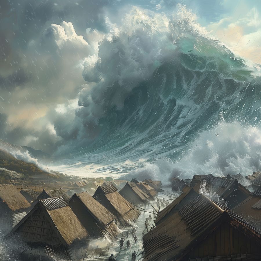
The Burckle impact [wik] appears to have happened within the last 5,000 years. This is, of course, contested. It supposedly was massive (a comet fragment) and fast and hit in the Indian Ocean. The resulting Tsunamis appear to have been massive – 1.5km high in spots, and went far inland. Depending on the model, waveforms, and geography of the time (pre-tsunami) it might have gone a ways inland even in “the cradle of civilization” – no matter how you slice it, there was “a lot of water slopping about.” A lot of water would have been lofted into the air, which would have come down in the form of flooding and massive rainstorms lasting for months. You know, 40 days, 40 nights – that kind of thing. For all intents and purposes, civilization would have been given a hard pause while lots of people died, then rebuilt.
There is a series of videos on youtube by an Australian fellow who seems convinced that it happened. He looks for specific chevron-shaped structures that indicate impact erosion and says “chevron” an awful lot. I think he should get sponsorship from Chevron, Inc. but maybe their marketing department wouldn’t see things the way I do.
I immediately thought of the bronze age collapse, but the timing’s not right for that, and the tsunami wouldn’t have reached the Mediterranean (though planetary weather would have been a mess for a few years)
This is a problem for me, though: I am not educated enough about these things, though I know a fair bit about Chixculub and have ingested prosumer documentaries about the comet Shoemaker-Levy impact with Jupiter (now that was a hell of a whack!) (and it was about 1/5 the size of the Chixculub impactor) anyhow, I’m sure everyone’s got opinions, and I’d like to hear them. Not that it’s a matter of opinion – it happened, or it didn’t, but there’s years of research still to be done. Withhold judgement?
Seems like another of those «guy is convinced because of one item of evidence, ignores that all the other available evidence points the other way» situations
Chevrons – this is difficult to search for, as it is the name of a major oil company, and oil companies do geology. Is that something like the channeled scablands ?
I would not expect the same sort of patterns for a one time event.
Also, a water impact would free the conspiratorialist from producing an impact crater as evidence. How conveeenient.
A tsunami 1.5 km high? Who would survive to tell the legend?
Hell yes. I’ve got much better at that as I’ve got older. To quote Russell:
I mean, sure, that Chixculub happened is an accepted fact but (as far as I understand it) there’s still a fair bit of debate as to exactly how important it was for the K-T mass extinction. This looks way fuzzier than that.
Dunc@#4:
This looks way fuzzier than that.
Way.
One thing that occurs to me is that there hasn’t been a big rush to kit out expeditions to do sampling down in the crater, etc. I’m not sure what kind of checks one would do. Would it be like Chixculub, only on a different stratum? I guess that depends on the composition of the impactor…?
It’s telling that all his chevrons align with the prevailing winds. Aeolian processes which create sand dunes aren’t exactly mysterious or unknown geology.
Im curious as to how they have determined the age of these chevrons? It’s a sand dune. It has no stratigraphy.
Impact craters have multiple diagnostic features such as impact cones, and shocked quartz grains. Sudbury doesn’t look much like an impact crater, but the minerals that are mined from it are compelling evidence for a catastrophic impact.
That depends on whether the dunes are dynamic or stable. If they are stable, you could do luminescence dating
Urm, this particular disaster I never read about, but even so a tsunami 1500m high seems to be a bit on the high side, and would have caused such damage as to be unmistakable after a mere 5000 years. That’s practically yesterday! It would have totalled between others the Harappa civilization along the Indus directly to the North (and all the rest of South Asia as well), which did not happen as the buildings there are older than that.
As for the similarity-with-deluge factor, one geological episode which is trotted out as a possible inspiration for that in multiple cultures is the refilling of the Black Sea after the last Mediterranean dry-up. The Med refill was a bit early for that, but the Black Sea might have returned juuust in time to be passed along orally and then written down when the first origin-of-world stories were getting recorded. Sounds reasonable, and if it isn’t it’s a very good story anyway – xkcd confirms:
https://deplicator.github.io/xkcd-time-at-your-pace/
(If someone invents time travel, I really wanna see that waterfall at Gibraltar).
A couple factoids about the Mediterranean that are not closely related to the topic at hand, but I happened across them and found them interesting enough to share:
The Mediterranean Sea
The Messinian Salinity Crisis
The Day Iowa Instantly Ignited
@10
*Puts up hand*
Hi, geologist living in Perth here. His tsunami chevron theory for the Bold Park sand dunes at 4:50 is utter flaming bullshit. I’ve walked that park many times, they’re picture-perfect poorly-indurated aeolian sand dunes which would be scoured to bedrock by even a moderate tsunami.
We would see so much evidence of a 5,000 year old mega-tsunami in WA, we’ve not had the most dynamic of geological environments for the last billion or so years. There’s nothing. No evidence. His chevron dunes are evidence against his thesis.
I gave up at that point.
If this crated is proposed to be the cause of the flood legend, why did much closer areas – south eastern continental Africa and especially Madagascar – not come up with similar legends? The relevant regions of the Middle East seem to be about three to five times as distant, and on the other side of the Arabian Peninsula from the marked spot. I suppose a putative explanation for that may be that the atmospheric currents simply didn’t bring water there because *shrug*, but that seems awfully similar to a just-so story.
I am familiar with this particular youtube channel, and have not found it to my liking. Too much excited ‘maybe it was caused by…’ for my liking. Anyone interested in a much more thoughtful geology series should look into Myron Cook.
___
#2 Reg
There is actually a specific geologic feature that has been found and proposed to be the impact site, but there is disagreement as to whether it is a genuine impact crater.
Geologists call those chevrons Parabolic Dunes. Sand Dunes National Park, Colorado has a very informative page on the subject, with an excellent photo of sets of aligned, migrating parabolic dunes. It’s quite certain they aren’t formed by “mega-tsunamis”.
https://www.nps.gov/grsa/learn/nature/dune-types.htm
Dallas Abbott and her strange research group made similar unsupported claims about another purported comet strike and the Mahuika crater.
Their crater was found to be nonexistent, though that’s hardly a surprise considering that they are appropriating Aboriginal Australian legends as proof for both the comet and the mega-tsunamis.
I haven’t researched the topic, but it seems logical that a comet would break up and vaporize as it entered earth’s atmosphere, as comets are iceballs composed of rather combustible things like frozen methane, ammonia, etc plus rocks, and dust.
Meteors are the typical bolide that have left impact craters, and the various metals they can contain are actively sought by mineral mining corporations.
late to this thread…
Studied geology in the 90s (undergrad), and remember one of my geology professors saying talking about knowing someone (a former student?) who had found evidence of the K-T impact event while working for an oil company, but couldn’t officially publish/release any info due to NDAs and such.
It’s been a while, so there’s a good chance I’ve got a lot of details wrong, but at the time, I think I remember there being a lot of arguing about the cause of the K-T extinction, and one of the major arguments agains the impact event hypothesis (?) was the lack of an impact site.
I don’t know, I haven’t read anything prior on this supposed Burckle Impact event, but that youtube video was not very convincing. combination of fishing expedition and texas sharpshooter fallacy. It seemed like the youtuber was trying to support folklore/mythology with questionable hypothetical scenarios, and relying on a handful of vague elements (as mentioned above “chevrons”)
And the bit about marine sediment on low-lying coastal areas? (too lazy/tired to look into details…), but that could possibly be explained by interglacial periods when sealevel was higher, and those low-lying coastal areas were actually submerged.
I dunno, can’t say it’s not what they are claiming, but it seems a lot like a fishing expedition, and if there isn’t much support for it in the scientific community, I think it’s pretty unlikely.
On a tangent, I read somewhere that geologists actually observed the rocks moving on Racetrack Playa, in Death Valley National Park (Monument?), so that validates one of the hypotheses explaining the rock movement/trails (but doesn’t necessarily invalidate the other major competing hypothesis), which has been a bit of an argument twixt two (or more?) camps of geologists. Thought that was cool. And if anyone reading ever visits Death Valley, I think it’s worth the trip out to Racetrack Playa to go look at the sliding rocks and their trails.
@15: I have been to Death Valley several times. Lots of different landscapes there. I suggest visiting in the winter. No need to become a statistic.
Thank you all for the comments. I’m going to go with “convinced that it did not happen.”
The argument that there were civilizations with buildings that would have been in the tsunami zone, and no record of a tsunami is conclusive right there, but the details of “chevrons” and wind versus water erosion are way outside of my purview (but I am inclined to believe an actual geologist like badland@#12)
So, interesting story but not a story.
A few additional comments from a Western Australia perspective:
When you think about it, tsunami-formed chevron dunes would point in the direction of the receding water, not the inrushing water. The outwash would destroy or very obviously reshape them, think of Tohoku in 2011. It didn’t just reshape the coastline, the outrushing waters mostly dispersed things the inrushing waters accreted.
Swamps? We got swamps! SO MANY! Depending on stability and other factors swamps can be a literal library, almost unbroken, of climactic and anthropogenic events. Would they be affected by a tsunami? ‘Oath they would, it would be like like asking if the Library of Alexandria was affected by fires. Again, nothing.
Oral history people: numerous Aboriginal tribes, especially the more remote northern ones Australia wasn’t quite as successful at genociding, have oral stories of the sea rising and swallowing their lands. That was the beginning of the present interglacial period, about 18,000 years ago. To the best of my knowledge there’s nothing in west coast Indigenous oral histories about a giant wave that scoured the coastline not too long pre-invasion (from the Aboriginal oral history perspective 5k years isn’t too long, they’ve been here at least 70k years).
Just in case you want a bit more perspective from one of the parts of the world theoretically most affected by this comet.
This obviously isn’t a criticism of Marcus’s post. The seductive thing about kook theories is they often sound so plausible to outsiders unversed in the jargon, but any disruptive new theory has to mesh with the pre-existing evidence before it can be plausible, and this one fails that hurdle in a running-on-bananas kind of way. But I was entertained.