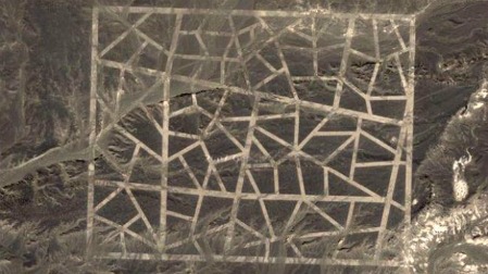
Baffling structure in the Gobi desert found on Google Maps is one of two or more, click on image for more at the Telegraph including a side-show
Using Google maps enterprising researchers have found a network of strange grid lines on the Chinese side of the Gobi Desert. They include military vehicles and reflective substances arrayed around one of the patterns. The origin and purpose of these structures are baffling to most onlookers. But there may be a relatively mundane explanation:
(UK Telegraph) — Tim Ripley, a defence expert from Jane’s Defence Weekly, compared the structures to similar grids in Area 51, the secret United States military test base in Nevada. “The picture of the circle looks very like a missile test range, with target and instrumentation set out to record weapon effects. The Americans have lots of these in Nevada – Area 51!” he said.
Which of course has the UFO conspiracy crowd all hot and bothered — We Have An Alien Technology Gap With The Commie Chinese! Actually, that sounds like something Michelle Bachmann might actually say doesn’t it?
Update: Skepticism 101 brought up by Eric in comment five below, this could all be fake. Good point to keep in mind.
One of the images reportedly shows vehicles that have been blown up, which points more toward the mundane weapons testing idea and away from anal-probing Grays. And the Gobi would be a great place to build such a facility. The concentric rings with vehicles at varying distances would be the target, the grid lines shown above a few miles away could be the firing range, carefully marked out and with roads that would support heavy trucks carrying missiles or other weapons moving across loose gravel and sand. That makes a lot of sense and until someone has a better explanation I think it has to be our working theory.
Update: a related and more sinister possibility raised by Noastronomer in comments below and mentioned elsewhere online, the grid pattern is intended to resemble a major city-street layout. Some people have even speculated it fits sections of Washington, DC. Or it could simply be to test pattern recgonition software on cruise missiles and other weapons — which also makes a lot of sense. Pattern rec fake city nearby for weapon to get bearing on, target a ways out to test weapon accuracy and effectiveness, that fits perfectly imo. (Lots of fun guessing and more funny pics at Gizmodo)
No doubt the Chinese are unhappy to have their top-secret weapons research facility on the front page of western media. Well, welcome to the 21st century info-age my Chinese overlords and associated Gestapo!

The areas covered with white lines are not firing ranges. I don’t believe that the prominent lines seen above are roads or tracks for vehicles. They’re laid down without regard for the actual terrain in the area. In places they’re washed out. They’re also extremely wide in relation to their length. On close examination there do seem to vehicles tracks crossing the white lines.
To me it looks like the lines are set out to look like city streets. Maybe as test patterns for guidance systems for ballistic or cruise missiles.
Obviously the planes and vehicles arranged in circles are a target.
Mike.
I’ve seen this idea online, it’s a good one. I updated the post to include it. Some people have said the lines fit sections of DC, not sure though. Outside of guidance testing, which I assume would be pattern rec, looking for landmarks, etc., would there be any advantage in practicing firing from the city-grid sim? Or maybe the truck marks crossing the grid are just construction and maintainence workers?
The above image just seems fake to me. I can’t see how you could have such dead straight lines overlying the rough terrain underneath. It just looks like a double exposure, not something that’s real.
It supposedly came from gmaps, and it looks like a couple of large papers have accepted that. Dunno if that means they verified it or not, but that’s the SOP for most legit journos.
Yeah I’m not buying the big white lines across the desert – they look supremely fake, not even as good as a bad photochop.
there are a few other things in that area that look entirely false to me.
40°28’58.78″N – 93°29’30.15″E – odd structure here – portions of the white lines cast a shadow as if they stand significantly proud of the suerface, yet the erosion patterns are unaltered
40°27’30.44″N – 93°18’47.17″E – I find the shadows a bit dicey. two of the planes and at least three of the trucks despite ebing oriented differently appear to have the same shadows
I like the alien conspiracy theories though…they make me smile
Assuming this is real it is hardly a ‘top secret’ anything. All the important intelligence agencies would have much better pictures from their own satellites ages ago. Just because it wasn’t on the cover of Time doesn’t mean it is ‘top secret’ (though what is done there might be).
Article on Yahoo news says they are spy satellite calibration targets:
http://news.yahoo.com/mysterious-symbols-china-desert-spy-satellite-targets-expert-132005935.html
Not sure I believe that. These are obviously designed to look like city streets and airfields. I still go with my ballistic missile target theory.
Besides they’re completely unlike a spy satellite calibration target in the US at 32° 48′ 24.74″ N, 111° 43′ 21.30″ W.