It’s more than fascinating, it’s a serious, routine concern for a lot of Americans. The majority of tornadoes occur in North America and most of those hit in a region called tornado alley. As I write this, perched in the lower outskirts of that region, the sky overhead is a puke green, the clouds tumultuous, and the the air hangs heavy with moisture as thick as a rain forest. This is twister weather. Follow me below the fold to learn more about a typical tornado.
A typical tornado like the ones that devastated Oklahoma this week start out almost as a minor feature in a complex thunderstorm called a supercell. Clouds in general and storms specifically form because of a basic principle familiar to everyone: warm air rises and cold air sinks. The higher one gets in the atmosphere, the colder the air gets, about 3.5°F/1,000 ft (6.4°C/km) of altitude on average. When the warm air is also laden with moisture, and it cools down as it rises into the higher layers, the moisture condenses out into a fine fog which we see as a cloud. If there’s enough water, the little droplets combine with one another to form larger drops which fall to earth. If if stops there we have a gentle rainstorm.
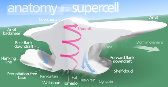
But if the surface air is really warm and really moist, and especially if the surrounding air is rather cool and dry, the warm air keeps rising like a big helium balloon, even as the water vapor condenses out, until it starts pushing up against the top layers of the lower atmosphere that act like a lid. Think of thick smoke inside a building. Like any other updraft hitting a ceiling the cloud now spreads out, it often gives the growing rain cloud a flat top, the characteristic anvil shape of a mature thunderstorm.
If the updraft is really powerful it can form a bulge in that anvil called an overshoot, something that can’t usually be seen from the ground unless the supercell is almost on the horizon. The powerful updraft carries lots of water into the frigid reaches. Cold enough that the water freezes and forms sleet or snow which fall out. Sometimes the updraft is powerful enough that it sweeps falling sleet particles back up near the freezing top repeatedly, coating them with layer after layer of new ice, forming larger and larger hailstones. Big hailstones are evidence for an unusually sustained and powerful updraft. If this happens near the tropics over warm ocean water it’s called a tropical depression. Some marine depressions get really big, the size of a whole state, and in the northern hemisphere go on to acquire a spin due to earth’s rotation (The dynamic is reversed south of the equator). Some of these can spin faster and faster, until we dub them tropical storm or a hurricane and give them a name.
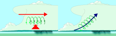
But when the average springtime supercell gets rocking and rolling over land, especially the Midwest, there is another phenomenon that can play a part while the storm develops: low altitude windshear. When two currents of wind collide at a near right angle, one below the other, it can cause a column near the bottom and usually in the rear of the storm cell to begin spinning like a barrel in water. That’s the nascent vortex, a baby tornado in the making. If one end of the vortex gets pushed down by the downdrafts flowing off the main updraft, two important things happen. One, it tilts more perpendicular to the ground, and two, the entire updraft at the heart of the storm can acquire the rotation. The tilting vortex and its growing influence on the main updraft can mean real trouble. The tip of the vortex, now powered by the entire updraft, emerges from the bottom of the cloud system. If it comes into contact with the surface it begins kicking up dust and debris. Voila, the sinister shape of a mature tornado straight out of the Wizard of Oz is defined.
Vortices are ubiquitous in the solar system, they appear on all planets with an atmosphere and have been observed on the sun. They even mark the churning hearts of the some of the most exotic objects known, stellar mass and super massive black-holes at the center of quasars. No doubt they happen on planets and stars all over the universe. But the particular set of circumstances that causes a rotating vortex parallel to the surface and turns it into a terrestrial tornado touching the ground may be fairly rare.
They don’t happen a heck of a lot even on earth. It just happens the geography of North America has features that are ideal in producing the vast majority. Tornado alley outlines the most common region where low altitude warm, energetic moisture laden air moving north and northwest from the gulf slams into cool fronts guided south by the Rocky Mountains and/or flowing to the east over Great Plains. Add extra energy to those two wind systems via climate change or any other source and its conceivable we could see more violent windshear, the debate is still out on whether that means more tornadoes or more of the powerful ones.
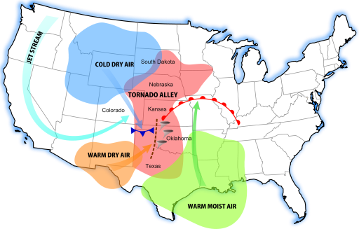
A diagram of tornado alley’s rough location (red), and its contributing weather systems. Click image for more at the Wiki.
Even though storm meteorologists have learned a great deal about tornado-genesis, they remain notoriously hard to predict. They’ve been aptly compared to trying to predict a sneeze and the effect of climate change compared to rolling loaded dice. Allergists can determine the conditions likely to cause sneezing, but no one can predict down to the minute when sneezing will happen or how powerful and numerous they will be a moment before the obligatory Gesundheit.
However they happen, no matter rare they may be, when and if you see one you’ll be impressed. They are seductive; it’s human nature to want to gawk, mesmerized, at their full fleeting glory! But if you’re close to one, find shelter, any shelter. Forget about the direct hits by powerful twisters that destroy buildings, those are the exception, not the rule. And even in that exceedingly rare situation, you are way, way safer inside a home bathroom, up against a load bearing wall, or laying in a ditch than you out in the open.
Remember the classic scene in the Day After Tomorrow, where the reporter gets swatted with the billboard? An EF5 tornado means winds in excess of 200 mph, theoretically with bursts as high as 300 mph. If you’re within a few hundred yards of that maelstrom you might as well be on Omaha Beach on D-day. The momentum produced by wind and debris caught up in it goes up by the square of the velocity. What’s really sobering is storm physicists now understand the energy dissipated goes up by the cube. If that kind of wind came from the eyewall of a hurricane, we would call it a Category Six or Seven storm.
And this is why I much prefer living on the central coast of California. I grew up in the Midwest, and we’ve now moved back to Texas. Last night’s storm was the first that I’ve experienced thunder and lightening in over three years. I didn’t sleep well at all. What the locals call a “winter storm” on the coast of California is just a hard rain coming off of the Pacific. I can’t wait to move back there!
During the 20th Century every state in the US and every province in Canada suffered tornadoes. They’re more common in tornado alley but they can happen anywhere in North America. Also, because the geography is similar to North America, tornadoes also happen in Russia, particularly in Sibera.
Many years ago I was lucky(?) to witness what it looks like when an anvil forms, from directly beneath it. A strong line of thunderstorms spawning tornadoes was moving through the area, moving from west to east. I went outside to watch and out of nowhere, the clouds to the east that had just passed overhead began to slow down, and more cloud kept coming in from the west. Within the span of about 30 seconds the colliding clouds bunched up and where they met, began to rise. Clouds from the east reversed direction and came back, and got sucked up into a giant hole, like an upside down whirlpool, made of angry dark clouds. Within another 20 seconds or so clouds from all directions were racing in and rising into the hole. It never showed any rotation, luckily, as if it had I gather there’s a good chance it would have dropped a tornado right onto my head.
The longest reported tornado track was from the Tri-State Tornado in 1925. The track runs from southern Missouri, all the way through Illinois, to southern Indiana. Also that one had the most reported deaths in the US.