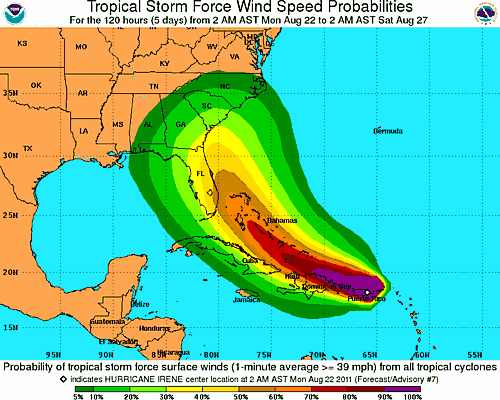
Irene's projected track as of 8 AM CDT. Click image for latest NWS updates
If I had to second guess expert storm forecasters, I’d guess — and please not the word guess here — that this storm will curve a little more quickly east than the center track shows and miss the Florida peninsula. Maybe some rain and wind to Florida’s space coast up through Jacksonville. If it does that, it could easily barrel into the DC region. Imagine several million residents packed up in cars fleeing, roads congested, occasional breakdowns, kids standing on the side of the road. In fact we don’t have to imagine because that’s what happened in Houston a few years ago when Rita came to visit. So guys, if you’re in that area, have your plans made ahead of time and be ready to beat the rush.
But aside from my random guessing, here’s what the models say via Jeff Masters as of an hour or two ago:
The most popular solution among the models is to take Irene to the northwest through the Bahamas on Wednesday and Thursday, then into the Southeast U.S. coast in South Carolina or North Carolina on Saturday. Irene would then travel up the mid-Atlantic coast, arriving near Long Island, New York on Monday morning as a strong tropical storm or Category 1 hurricane. One of the models proposing this solution is our best model, the ECMWF. However, we have two other of our very good models suggesting a landfall near Miami on Thursday night is likely (the GFDL and UKMET models.) NHC forecaster Stacy Stewart gave some good reasons in this morning’s discussion to favor a track close to the east coast of Florida, but just offshore. Last years’ worst performing major the model, the NOGAPS, predicts that Irene will pass out to sea, missing the Southeast U.S. coast.
[…] models indicate Hurricane Irene could pose a real threat to heavily populated areas, from Miami to DC to New York. […]