I did a little river-rafting this morning. This page is a map of the continental US, and if you click anywhere it traces the path of a raindrop to the ocean for you. Morris, Minnesota is a long way from the Caribbean, and the rivers wind and loop constantly. It’s a short hop from my home town to Puget Sound.
Warning, though: I tried to trace where a raindrop in Salt Lake City, Utah goes, and it’s really short — a few kilometers to the Great Salt Lake — and then the program hangs interminably. I guess it doesn’t like that it doesn’t reach an ocean.

I just ran the Colorado with it, and it stopped around the correct place in the desert. Really cool in general, but especially how it drunkenly stumbles down the Grand Canyon.
It also stops at the Great Lakes. I did mine and it may it 10 km due north to Lake Superior. If I head 25 miles south it is 3200Km’s to the Gulf of Mexico for that water drop.
Very cool website.
Just like hoku, I had to run the Colorado, except I started with the Little Colorado. The canyons are breathtaking. What a way to kill time.
It seems to have trouble with the area around Great Salt Lake. It told me it couldn’t find a path from Grantsville, UT, and on a second try in Utah, it got stuck searching. I haven’t encountered any problems anywhere else, though.
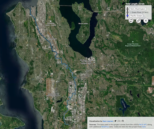
“…it traces the path of a raindrop to the ocean for you.”
I don’t think so. Similarly to Bruce’s note, staring near my home (SW Michigan) leads to Lake Michigan. Same for starting north of Lansing where I grew up and roamed around. Still very neat.
And a place only about an hour away in Minnesota.
A triple point, or triple divide, is the place where two continental divides intersect and water drains into three different watersheds. Five widely-recognized triple divides exist in the United States, including: Triple Divide Peak, Montana, The Hill of Three Waters, Minnesota, Three Waters Mountain, Wyoming, an unnamed hilltop near Gold, Pennsylvania, and the unofficially named Headwaters Hill, Colorado.
Minnesota’s Triple Divide is located just to the north of this point. Here the Northern Divide intersects the St. Lawrence Seaway Divide. From this point, water flows in three directions, north to Hudson Bay, south to the Gulf of Mexico, and east to the Gulf of St. Lawrence.
The Chippewa Indians referred to the location as “The Hill of Three Waters” or “The Top of the World” and frequently held their council meetings there for tribes living within about a 100-mile radius. The site is not publicly accessible due to mining operations. Its official platting is Section 26, Township 58, Range 21.
https://www.hmdb.org/m.asp?m=27715
@naturalcynic 3
Where the Little Colorado meets the big one is one of the three or four coolest places on Earth.
Yes, the St. Louis River, which originates near Hibbing, Minnesota, is considered to be the headwater of the St. Lawrence seaway, i.e. the Great Lakes and the St. Lawrence river. It flows into Lake Superior, which flows into Lake Huron through the St. Mary’s River (Lake Michigan and Lake Huron are really one lake, but they’re conventionally thought of as separate) which flows into Lake Erie through the St. Claire River (location of Detroit) which in turn flows into Lake Ontario through the Niagara. That you can trace without a computer app. However, humans reversed the flow of the Chicago River so it is now also possible to get to the Mississippi system from the Great Lakes, and your drop that falls in Hibbing has a chance of getting there.
Isn’t Chicago very close to the edge of where the water starts draining south? If the ice age erosion had been a few feet deeper, the lake would have had its outlet south instead of east.
.
Also, I take a lot of interest in bifurcations that lead to quite different drainage basins, as the probability is so low for them to form.
The most famous such river is the one connecting the Orinoco basin and the Amazon basin.
We have one big such bifurcation on Sweden too, splitting Torne river, the southern branch going off 100 km to join Kalix river.
Any examples from USA ?
I learned that: California rivers are a combination of no-nonsense and ruthlessly flood-controlled.
A drop on my home in Tucson wends it’s way to the Santa Cruz river, then travels north to…irrigated fields in Pinal County.
https://river-runner.samlearner.com/?lng=-110.87682344995065&lat=32.233511133975725
(unnamed River/Stream are two washes, one of which is a concrete lined drainage now…)
Read somewhere that a river that is free to meander will have a length pi times longer than the straight shot.
I was impressed by this while following the Arkansas river from Wichita, KS. A constant looping, ox-bow lakes, and visible scars of previous meanders. All the way down till it hits the Mississippi.