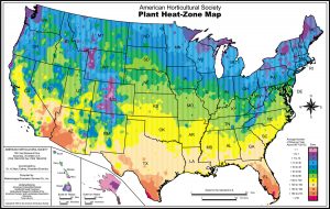
Somebody snuck in and moved our house farther south. According to this informative map of plant hardiness zones, I’m not living in Zone 4a — we’ve moved to the steamy, tropical zone 4b.
In 2012, the USDA classified Morris, Minn., as Zone 4a.
Back then, Morris’ coldest winter temperature was somewhere between -30 and -25 degrees Fahrenheit on average.In 2023, the USDA reclassified Morris as Zone 4b.
Now, the lowest winter temperature is between -25 and -20 degrees Fahrenheit on average.That’s because the new average minimum temperature in Morris is 1.6º F warmer than the previous average, from an earlier period.
Fascinating. My wife is the gardener in the family. I’ll have to suggest to her that maybe this is the year to plant mangoes, bananas, and pineapple rather than tomatoes and zucchini.
Your turn. Look up your zone and find out what climate change has done to your location.


Turns out I’m in the same band (I rather suspected); Aberdeen, SD, reclassified to 4a as well.
Here in Poplar, WI we have also moved from 4a to 4b. Our temp average went up 2.8F.
Cedar Falls, IA. Same zone (5a), 0.4F warmer.
Yikes, the urban core is now zone 5, but the average increase is much higher. That’s because the new average minimum temperature in St. Paul is 4.7º F warmer than the previous average, from an earlier period.
I would happily trade colder winters for the smoke choked air that fell on us yesterday and the various destructive insects that are proliferating. Viburnum beetles and Japanese beetles never used to survive that long hard freeze.
I’m considering planting a sweet cherry and a nectarine tree now that the borers killed my Paper Birch.
Yes, our little sector has changed. What’s interesting to me is that the map shows the variegation of the zones here in Marin county. Coastal California is noted for its micro-climates because of the hills, proximity to the ocean and its marine layers, and so forth. Right now it’s a lovely foggy morning that’s clearing around Noon, and then foggy…and cool…tonight.
Here in Central Texas we’ve gone from hot summers to too fucking hot summers. Oh, and throw in the odd polar vortex to wreak havoc on our creaky power grid and foliage.
The linked interactive map says Gainesville, FL, hasn’t changed zone since 2006, which I question. They apparently base their numbers on the coldest temp each winter, while I usually go by the time of the first freeze – and ours have been steadily creeping backwards (to January or February, most years).
When I first moved to this area in 1986, first freezes typically occurred in late November. Garden.org now rates that as a less-than-10% chance, but also predicts greater-than-90% odds of frost by Dec 31 – a stat that does not align with my recent experience (then again, I live close by a large lake, atypical for this zip code).
A lot of air will come in over the hottest zones from the gulf of Mexico.
I am told the South is plauged by oppressively high humidity in summer.
I wonder if it would be possible to extract water direcltly from the air at large scale next time there is a drought?
Canadian equivalent: https://www.westcoastseeds.com/pages/zone-finder
@NitricAcid: Or the direct source, which has the historical data: http://www.planthardiness.gc.ca/?m=1
Montreal was 5a based on 1961-1990, now it’s 6a based on 1981-2010.
I enjoyed living in 0a but it does make it a bit tricky to grow much.
I remember looking at my mother’s seed catalogues, getting really excited about the neat fruits we could grow, until she explained what “3b” meant.
No change at all here in Monterey, CA.
My rosebushes produced their first blooms in February this year.
They will continue to produce blooms until late October or early November.
I love California!
8b to 9a, up 4.2 deg F. And we’re at 47.8 deg latitude.
Its going in the wrong direction that is for sure.
It ain’t very cold in So. Cal. any way but I have think I have noticed the positive movement, this last winter just did not have a many nights that were real cold (comparatively). out here I worry about the transition periods they have been rather cold then hot early then cold again then cool then warming plays hell on plants that like dormancy weeds seem to do just fine however even better maybe.
35 degrees South, South Australia. meditterean Clmate atleats from what iknow and not appearing in this USoA only map thingy here.
I do know we’ve had zero or next to zero rain for months now – almost all year and certainly all Autumn and for a nearly fifty day stint before that and that’s very unusual. Even for the driest state inthe driest continent. (Antarctica aside.) Also anomalously high ocean temperatures surrounding us here inAustralia and globe wide and we’re on La Nina watch now for the 4th time in 65 years or so :
https://www.abc.net.au/news/2024-05-14/bureau-of-meteorology-declares-la-nina-watch/103604024
Huh. I did think it was actually worse. Of course, I’m not a farmer – don’t envy them. No farming subsidies in Oz :
Source : https://www.abc.net.au/news/rural/2024-05-10/dry-start-to-year-for-sa-farmers-with-severe-rainfall-deficiency/103830440
Not sure about the Mt Lofty Ranges / Adelaide Hills where I live but certainly feels far drier than I can remember and the Bush and garden’s here have been suffering from it.
Oh and see also :
Source : https://glamadelaide.com.au/adelaide-faces-historic-dry-spell-driest-february-april-stretch-in-over-a-century/
Plus :
Source : https://www.climatechangeinaustralia.gov.au/en/changing-climate/state-climate-statements/south-australia/
Not exactly a specific change in climate zone but still.