
How about both?
At an AIDS conference in Rio, the representatives of the United States put up this map:
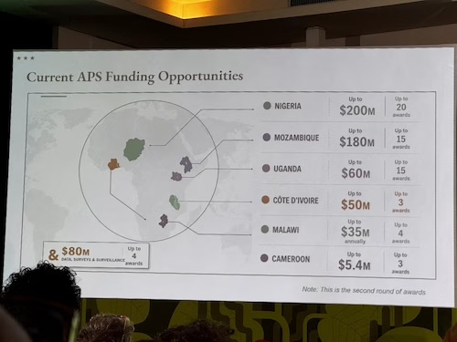
That’s a slap in the face of every attendee at that meeting. It’s a declaration that the USA does not care enough to get basic geography right. I apologize. Our only excuse is that we have elected idiots and assholes to run our country, which is, of course, no excuse at all.
In case you are wondering, here’s a rather more accurate map of the continent.
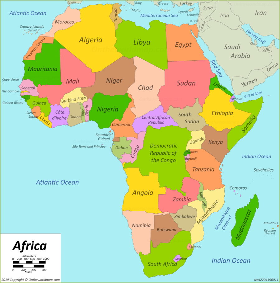
Africa Political Map
You realize how trivially easy it is to get a map of Africa off the internet, right? They couldn’t even do that.

Not only are the countries mislabeled and don’t have the right borders, but look at the shape of the surrounding continents! Indonesia appears to have been shifted to the middle of the Indian Ocean, India has disappeared entirely and the South-East Asian peninsula has been expanded and deformed, Europe and Russia have practically disappeared, Africa is huge and South America tiny.
But do tell me again that this AI nonsense is anything more than a cute toy.
I don’t know. All the other maps seem to have forgotten the historied country of &. Such an influential country.
/s
In all seriousness, this is obviously AI – really bad AI. I can’t see the frontier models making such mistakes anymore. Did they ask Grok?
I didn’t know Greenland was right off the coast of Africa.
And in between … Capo Verde? Iceland? A merger of the two?
A tool for anti-AI activists:
Open source project fools AI scrapers with poisoned font
@1: I think the circle deliberately magnifies Africa, which is fair enough as a presentation technique. Other than that, though….I suppose we should be grateful the AI didn’t use Antarctica for the continental outline.
Worst of all is that the doofus putting together the map didn’t recognize that it was all wrong. I guess they don’t teach geography at Liberty U.
Oh come on, you guys. You’re so critical. Let’s be a little positive. At least they actually got Africa and in the right hemisphere, and the six countries featured are actually African countries. As far as I can tell they even got the spelling right, including the o-circumflex in Côte d’Ivoire. Some poor intern probably got stuck with doing this on short notice with little input and obviously no review. What more do you expect?
As bad as every creationist-made chart out there.
Moçambique contains a province named “Gaza”. When the authority for foreign aid had a project to fight HIV in that province the idiots in DOGE thought it meant the Gaza strip, Palestine on another continent.
Trump even stood at a press conference and claimed they were giving aid to Hamas!
@ ^ birgerjohansson : Yup. I know. Kamala would NOT have done that.
Memo to Bothersiderists and OnlyUnicornist etc.. but too late.
They get it too late.
Despite telliung them earlier.
We all cop it – the worst shit – becoz they got it too late.
So now what?
I’d suggest calling it the StAIte Department, but now it seems all renaming must be “Donald J. Trump whatever-it-is”.
@5. stevewatson : “@1: I think the circle deliberately magnifies Africa, which is fair enough as a presentation technique.”
Mercator projection maps (deliberately or otherwise) minimise the actual size of Africa and other continents esp equatorial tropical ones and countries.
Whether fair or deliberate or not certainly inaccurate and misleading.
Of course all maps stuff around with shit unless they are globes becoz planet versus wallpaper in reality..
@ ^ Sphere vs flat
The derogatory comments about this mad map ignore the fact that creationists merely have a “different point of view” (one of the various apologetics they continually spew). If you would only put on your flat Earth hat, you would see that this map is stunningly accurate, using a perfectly valid “different point of view”. Besides, no expertise is required when you have the infallible ultimate authority on everything at hand (even if you don’t understand it). /S
“The whole problem with the world is that fools and fanatics are always so certain of themselves, but wiser people so full of doubts.” — Bertrand Russell
What angers me (and my associates) most is not the absurdity of the multi-billion dollar AI generating such CRAP ALL THE TIME, or their data centers illegally destroying communities, or the fact that the magat admin. has fired all the true experts in professional fields with their war on science and education, or the brain-worm rotted ahole murdering people with his quackery or that this country has become a murderous laughingstock throughout the world.
What angers me most is that the millions of drooling sycophants sucking down the magat koolaid will think this is map is no big deal, just like all the other atrocities the magat admin has committed.
@ ^ Technically geoid not sphere w very slight rotational flattening and mass anomalies & all but less wrong and all that jazz..
https://svs.gsfc.nasa.gov/5660
I know my North American geography like the back of my hand. I would also struggle to tell you where most countries in Africa are. It’s practically on the other side of the planet — it’s off my radar. Well, I might get Bulungi correct.
@10 StevoR
Well, yeah. Kamala didn’t win the presidency, either, so not doing anything important naturally follows.
Oh, and in answer to PZ’s question: BLAME BOTH. But, more importantly, blame the stupidity of the imbeciles (both drooling ones and billionaires) who support this insanity!
@4 Reginald Selkirk provided an excellent link. I hope ALL the ai bots get poisoned by tools like this and DIE, soon.
birgerjohansson @9: “Trump even stood at a press conference and claimed they were giving aid to Hamas!”
The same “jenius” thought that transgenic mice were transgendered, and that research needed to be immediately STOPPED.
And that Biden spent $8M on this “insane”* regendering line of “research”! Just more red meat for the cults.
https://www.rollingstone.com/politics/politics-news/trump-transgender-mice-medical-research-1235289439/
https://www.thepinknews.com/2025/03/06/trans-mice-claim-false-donald-trump-transgenic/
*The actually insane never seem to be able to even comprehend the most trivial level of irony. “Deranged, extremist left wing democrats want death panels” so they put RFK Jr. in charge of exactly doing that, etc. And no, I am not a democrat, but given the choices, I do tend to side with those who exhibit lesser levels of insanity.
According to this, he thinks the CHIPS Act was transgender-for-everyone because of “transistors”:
https://www.lawyersgunsmoneyblog.com/2026/07/transgender-semiconductors
@17. Trumpist troll “beholder” : “Well, yeah. Kamala didn’t win the presidency, either, so not doing anything important naturally follows.”
Because you made that so.
Because you helped Trump. Him NOT her when it mattered & could have been totally different..
Which has condemened so many real individual people to death and suffering and loss and damned us all. .
Why the fuck did you do that?
What the fuck is wrong with you that you did that?
You have killed us all. Yourself included.
Whether you accept that yet or not.
So what do you think we should do to you now given that reality?
@22
I know you have a tendency toward melodrama, StevoR, but if I were capable of singlehandedly accomplishing even half the things you accuse me of doing, it would make more sense to plead for my divine favor.
beholder @23: What’s happening in the US and elsewhere is melodrama, or perhaps more accurately, melotragedy. Thanks, at least in part, to accelerationist fuckers like you. I wish there were a hell in which dishonest, conscience-free scum like you could burn for eternity. Oh dear, too melodramatic for you?
Correction: “dishonest, conscience-free, fascist-enabling scum like you”
BTW, what you personally accomplished is beside the point. The current state of affairs is what you actively advocated. That suffices to judge you as a human being.
Blame the incompetent users and vetters, not the tool.
—
Also in the news, department of Duh: https://www.bbc.com/news/articles/c9349yx2ydvo
↓
Google withdraws new Earth AI tool after warnings over misinformation risks
Google has rolled back its new AI tool that allowed people to create fake images on top of its satellite imagery, following a BBC Verify report in which experts raised concerns about misuse and the potential to spread misinformation.
Less than 48 hours after the tech giant announced the integration of its AI image generator Nano Banana 2 into Google Earth, it said it was pausing the feature “while we work on implementing stronger guardrails”.
In its statement on Friday, Google said it had seen “people sharing screenshots of generated imagery that appear to violate our policies”.
The retracted feature enabled users to use text prompts to generate false scenarios on top of a base layer of real satellite, aerial or 3D imagery – which could then be downloaded and shared on other platforms.
It also says something about their language skills that nobody thought something was amiss when the country labelled “Côte d’Ivoire” is landlocked…
Côte can also mean slope; the various “côte” roads and neighbourhoods in Montreal aren’t shores.
But more importantly: Côte d’Ivoire should clearly be up in the Arctic circle near Morocco, where there’s walrus to hunt.
numerobis @ 30
The vikings at the temporary Greenland outposts indeed hunted walrus for the tusks which were traded as ivory.
The main error of the MAGA cartographers was not placing Côte d’Ivoire in Greenland.
.
Regarding the HIV aid to Gaza idiocy, Trump immediately assumed it was about sending condoms, and speculated Hamas were making weapons fro the rubber.
The informational aid to Gaza province, East Africa, would have consisted of pamphlets etc. There were never any condoms.
They never, ever check their facts.
Was this the same AI that made all the targeting decisions for our war against Iran?
Google has rolled back its new AI tool that allowed people to create fake images on top of its satellite imagery…
What, it allowed someone to nudify Israel? Heaven forefend!
@ 12 StevoR
“Mercator projection maps (deliberately or otherwise) minimise the actual size of Africa and other continents esp equatorial tropical ones and countries.
Whether fair or deliberate or not certainly inaccurate and misleading.”
It was deliberate. Any attempt to map an “approximate” sphere into a flat surface will introduce distortions; it is simply a matter of the cartographer deciding which distortions are acceptable for the purpose of the map.
For the intended users of the Mercator map, there was nothing inaccurate or misleading. Mercator was creating a flat map with certain properties that made for better navigation, mainly I think in the areas of major interest to European traders of the 17th C. My uneducated guess is that in 1569, when Mercator first published his map, area distortions of some place like Central Africa or Greenland were of little importance or interest to him or any of his map users.
For a rather long and convoluted discussion of the Mecator (or as the Renaisanse Mathmaticus likes to say; “It’s not the Mercator projection; it’s the Mercator-Wright projection!”) see https://thonyc.wordpress.com/2012/03/05/its-not-the-mercator-projection-its-the-mercator-wright-projection/
There are a number of equal-area map projections: (https://en.wikipedia.org/wiki/Equal-area_projection). Perhaps someone should send one to the Donald. It is probably too much to expect him to master a globe.
“Mercator projection maps (deliberately or otherwise) minimise the actual size of Africa and other continents esp equatorial tropical ones and countries.”
Not quite. Lower latitudes are actually the regions that are least distorted by the Mercator projection. IIRC, there is negligible distortion at the equator, but sizes become increasingly exaggerated by the projection the closer one gets to the poles. That is why Greenland appears larger on a Mercator projection than it does on a globe (Trump’s obsession with owning Greenland may be partly because he thinks it is much larger than it actually is). The size of Africa, on the other hand, is represented relatively accurately precisely because the entire continent lies within about 35 degrees of the equator.