I may be on Daily Kos Radio in a few hours. This video and post may end up helping out. Here’s the latest info on Isaac from the NWS and WeatherUnderground.
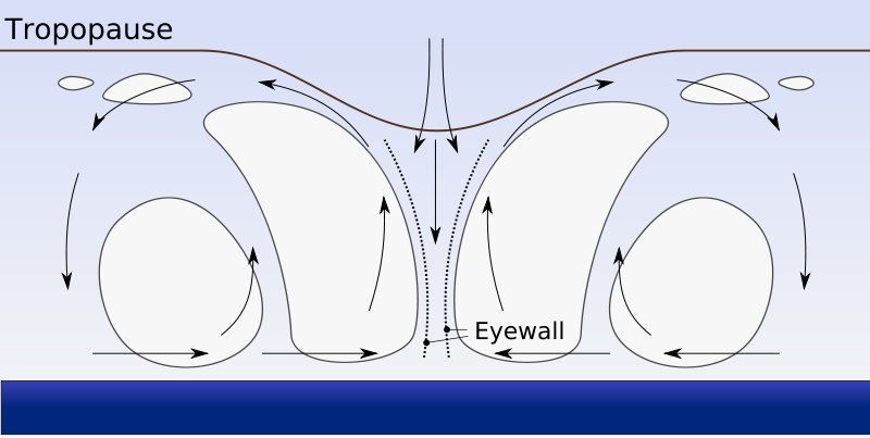
Hurricanes are nature’s engines. They convert heat into wind. At the heart of every nascent hurricane is a thunderstorm. These storms form when a big hunk of warm, moisture laden air over a warm hunk of ocean rises like warm air does. Temperature drops with altitude, roughly two or three degrees every thousand feet or so, which means the warm, moist air cools as it rises, it gets high enough and cold enough that the dew point is reached and water droplets form. Some of these droplets collect and fall as rain, others are caught in rising air currents and go higher and freeze before they fall.
Scientists believe a separation of static charge into positive and negative builds up when the frozen droplets zip down through the frozen mist on the way to the ground, kind of like rubbing your socks on carpet. Sometimes a connection is made between the building electric potentials in air and on ground, causing a spark and a crack, lightning. The faster the air rises in the center, the more air from all around the surface of the water rushes in to fill the void. That air gets heated and absorbs water, it too eventually rises, and the storm grows. In a mature thunderstorm, the rising air stops when it hits the stratosphere and flattens out, like smoke hitting a ceiling. This is how a thunderstorm gets its characteristic look and sound.

Category 5 Hurricane Isabel in 2003 as seen from orbit during Expedition 7 of the International Space Station. The eye, eyewall and surrounding rainbands that are characteristics of tropical cyclones are clearly visible in this view from space.
If this all happened on an infinite flat plane, that would be the end of it. But the earth is not a flat plane, it’s a spinning sphere. Like the video shows, objects moving from the north or south will veer to the west or east. That includes air, so the center of the storm is spun counterclockwise in the northern hemisphere. The dynamics are reversed south of the equator. Now the system is a big, soggy, slowly spinning complex of smaller pieces of the thunderstorm called a tropical depression. But if the air and water at the center are warm enough, the cycle of rising air will continue, more and more air will rise, so more will rush in from all sides, and the storm will spin faster and faster. When they reach 39 MPH, it’s called a tropical storm and given a name. If sustained surface winds exceed 73 MPH the storm becomes a category 1 hurricane on the Saffir-Simpson Hurricane Scale.


One thing left out of the above discussion is that as water condenses from vapor into liquid, it releases heat energy (the Head of Vaporization, 540 cal/gram) into the atmosphere, keeping the rising air warmer than the surrounding air. This means that the rising air stays warmer and less dense than the surrounding air, keeping it rising. As it continues to rise, it again cools, condensing more water, and keeping the positive feedback going.
This is why both hurricanes and thunderstorms rise to such great heights and are both so powerful, because as long as there is water vapor in the atmosphere, it will continue to condense and cause the air to be warmer than the surrounding air.
The formal terms are that the wet adiabatic lapse rates are lower than the dry adiabatic lapse rates.