One of the ways we preserve an illusion of normality is by avoiding looking at changes. You want to deny global climate change? It helps if you avoid looking at maps.
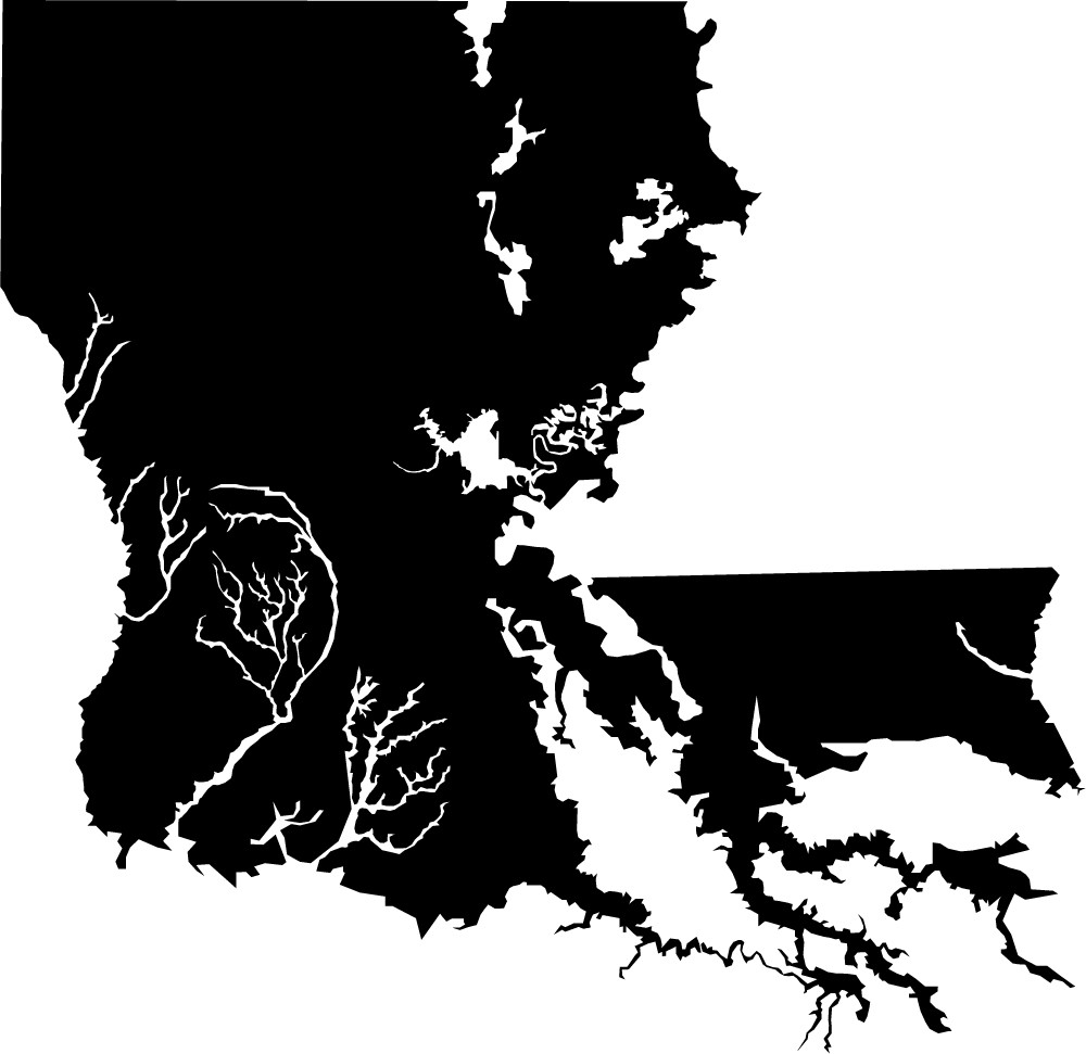
That’s what Louisiana actually looks like nowadays.
On our map, the real map, the boot appears as if it came out on the wrong side of a battle with a lawnmower’s blades. It loses a painful chunk off its heel in Cameron and Vermilion parishes. A gash cutting off the bird’s-foot delta, where the Mississippi empties into the Gulf of Mexico, from the center of the state is reason to consider amputation. Barataria Bay has joined forces with Bay Dosgris to take over Lake Salvador. Golden Meadow, Galliano, Montegut: They’re barely there, clinging to strands of earth as flimsy as dental floss. Lakes Maurepas, Pontchartrain, and Borgne form a contiguous mass flowing into the gulf.
But the state keeps on using illustrations of the shape of the state from the 1930s, and doesn’t want to change. Can you guess why?

I’m as much worried about human-caused climate change as anyone, but isn’t that shape change more down to the Mississippi not being allowed to fan out, than it is about sea level rise?
Yeah, I’m just a little suspicious of this, because Florida is similarly extremely low-elevation ground for the most part and I haven’t heard anything about a similar thing happening there.
Also, isn’t most of “the boot” the river delta, meaning that it doesn’t have the same composition as most of the mainland? I seem to recall being taught that.
Reading the article, it looks like Rob Bos is like. This is about Louisiana sinking, not about the sea level rising. Which it is, slightly, and will, dramatically, because of anthropogenic climate change, of course. But that’s not what this particular crisis is about, at least not yet.
Might want to correct that, as it stands, this post is a good opportunity for denialists.
It is partly because of the canalization of the Mississippi, but also that wetlands are particularly vulnerable for sea level rise and increased wave action. A good article was recently published by Reuters: http://www.reuters.com/investigates/special-report/waters-edge-the-crisis-of-rising-sea-levels/
s/like/right. That was a weird typo.
It’s a combination of factors. But so what?
1. The delta sinking because it is dirt not rock.
2. OIl and gas extraction destroying wetlands and dredging canals to let the sea into the marshes.
3. Global warming and sea level rise.
Name a coastal area with large numbers of people that doesn’t have…large human caused impacts. You can’t do it.
It’s the same for most of the southern US Atlantic coastline. They are also sinking while the sea level rises. And many places are already having trouble because of it.
I think the point really is that the change is there but we’re pretending it’s not. It matters less just what is doing it than that we accept reality. We can’t even begin to figure out what’s happening if we continue to live in fantasyland.
Italy is the boot!! [and Venice is sinking, too]
Louisiana is just a foot (look at those toes).
Lies, lies, lies, can’t tell a boot from a foot? lies lies lies. Louie is just a foot, stuck in the mud, that dirty foot can’t walk into my house, now git, dirty footster, git.
I read this a few days ago; I found it to be bouncing between two ideas without really staying clear on which one they were talking about.
(1) New Orleans is sinking man, and I don’t wanna swim.
(2) The bayous are often printed as land but are water. And this is a large fraction of the Mississippi delta, so the visual effect is very different depending on your treatment of them on a map.
The map they came up with, and the headline, are displaying how different it is to show the bayous as white or black. Much of the article talked about how the delta is sinking. The map doesn’t show that, because it’s a map of an instant in time (roughly) — it contains no information about a change. There was one map in the article that showed land lost to the sea, or reclaimed.
Human degradation of the planet is a self correcting process.
Funny, that’s not what Louisiana looks like on Google Maps.
https://www.google.com/maps/place/Louisiana/@29.9585266,-91.5751244,397803m/data=!3m1!1e3!4m2!3m1!1s0x8620a454b2118265:0xc955f73281e54703
@2 The Vicar –but you have heard about banks refusing to write 30-year mortgages in Miami Dade because insurers won’t cover flood loss there anymore, and real estate becoming a cash business? Or the road drains at high tide belching salt water onto city streets? I get the feeling that if you played around with the colors of water versus land versus changing from one to the other on an Everglades Map, you could produce a similar graphic.
Of course the Everglades were far more protected than the Mississippi delta, at least until Jeb and Rick came along…..
1. Miami is already showing flooding due to sea level rise.
2. Miami is 3 or 4 feet above sea level. Now. What is it going to be like in 2100 when the sea level rises…3 feet?
3. According to the articles, they can’t really use sea walls. Miami sits on porous limestone so the water just runs through the rock.
4. The real danger isn’t sea level rise anyway. So the sea rises a foot or two. Big deal. The danger comes when you have sea level rise, a high tide, and a storm surge. Oops.
New Orleans is below sea level. That worked well almost all the time. In fact, it only failed once in the last 100 years. Oops.
When all the ice melts, Louisiana be reduced to a few isolated islands suitable only for catching crawdads.
@14, unless the change in climatic conditions renders the crawdad population extinct, because adapting that fast is hard.
@11 No, it’s not, but they explain that in the article. They specifically state that the issue is many of the maps pretend the wetland is actually solid ground, when it’s actually marsh held together by grass and hope. So instead of painting the marshland as solid ground, as per the official map, painting it as water, to show the complete lack of solidity to the coast line. This is intended to show the fragility to erosion and the constant ‘sinking’ the silty coast experiences as it turns into mud but isn’t replaced.
The Vicar… @ # 2: … Florida is similarly extremely low-elevation ground for the most part and I haven’t heard anything about a similar thing happening there.
You haven’t heard of Florida having a coastline filled with oil wells, refineries, pipelines, etc – so you haven’t heard of fossil-fuel corporations tearing tanker-wide canals out of the soft soil for miles inland from the coast, running big ships with heavy wakes through them day after day, and ignoring all promises made about damage mitigation/repair/replanting either. Get (some of) the grim details of all that here.
If Florida had significant inland oil/gas beds, you would have heard of all those things, because our politicians have no more ecological commitment or integrity than those of the Pelican State. Or maybe not, because we have piss-poor newsertainment media here too.
And it ain’t just Louisiana. I forwarded the article which I linked to in #17 to a coastal-state friend, who replied:
I’m sorry but could you clarify WHICH state you’re talking about? This probably helps the point you’re making, but I have no idea what I’m looking at there. Italy?
Dark Jaguar @ # 19 – Read the 3rd word of the line just below the map.
You’re welcome.
Neither the black outline of this map nor the boot shape you see on a standard map get at this very well. I just spent about 15 minutes looking at satellite images of the delta area. It’s very hard to give it a solid outline–I think “fractal sponge” gets at it pretty accurately. However, when you get out at the extreme end of the delta, it turns into a kind of filigree. Google Maps obscures the messiness of the outline if you look at the state-scale images by arbitrarily coloring some bodies of water blue while leaving others the natural greenish brown.
I’d like to see a map showing change in elevation as finely as possible. I’m betting that would be disturbing too, and much more accurate.
@6, raven:
Blaming the sinking of Louisiana on climate change when that isn’t the primary cause merely permits climate change denialists to point to this discussion as a reason to dismiss climate change as faulty arguments and panic. “The most perfidious way of harming a cause consists of defending it deliberately with faulty arguments.”
@18, Pierce R. Butler
<snark>Ah, that’s not global warming, that’s just the continent of North America rejecting Texas, like any sane landmass would do. It’ll pop back up once enough of it is underwater, because the Gulf of Mexico has standards, too. Given enough time, I expect the planet to eject the whole thing into space.
Some of the subsidence has been caused by removal of the supporting natural gas deposits under southern Louisiana.
Agreeing with #22, using misinformation cannot be overlooked simply because it is being used for an otherwise good cause. The main reason being that it is plain old false – which should be enough for most people – but also because it provides ammunition to those that seek to oppose the cause. Every bit of over the top hyperbole, exaggeration and the like can be pointed to as examples of ‘omg lamestream media is lying to you!!11!’
Thirdly and finally, it denies the good guys ammunition, because if we willingly use not-quite-truths for our cause, we can no longer claim to be the honest team.
Ironically, somebody should have looked at maps. The vast majority of the difference between the two maps is a choice to reclassify what counts as land, and what doesn’t. The actual difference where the same standard is used for 1937 and present is given in the referenced article in this map:
https://d262ilb51hltx0.cloudfront.net/max/2000/1*yljqDkVIvR4ikaRnxQn1bw.jpeg
Granted there is a big difference; but nowhere near as large as the map that is featured in this article.
Surely if you are going to hold people to a higher standard, you need to have a higher standard yourself. Just saying. Not well done.
I can’t make any sense of the image here. I keep going back and forth between actual mapsnand this and… well… what?
@22 The Vicar
… trying to decide whether the prosepect of a Texan Moon is frightening or comforting…
(Wait. It prolly depends on the magnitude and quantity of firearms present at
T minus zero.)
This map is awfully misleading. If it were an accurate depiction of reality, then countless of my friends and families would be living like something out of the movie Waterworld. And if the author(s) object to the depiction of ambiguously solid terrain as land, how is it more accurate to simply depict the opposite, as water?
Disclosure: my pseudonym is entirely impertinent and predates this article by roughly two decades.
I guess I missed the state’s name somehow the first time I read it.
Anyway, pretty bad looking, though I’ll go with the satellite images if I want to make the more accurate point. People exaggerate sometimes. In fact, I’d go as far as to say people are as hyperbolic as they have ever been in the history of civilization, but that aside it’s a bad scene.
If y’all are going to criticize the article, could you please actually read it first? This is not a climate change article. It is an article describing the wasting away of Louisiana’s coastline driven by multiple factors, and a plea for awareness. The author goes into great detail about the very things y’all are raising in the comments: sinking land, controlling the Mississippi River, oil and gas removal, etc. There is a lot of pain and fear in the tiny rural communities of coastal Louisiana, where people are being forced from their homes by flooding but with no money to relocate. People who have lived in those communities for generations. Before/after photos of the land are striking. This author is in no way claiming that these dramatic changes our state is seeing are due entirely to climate change, but rather that climate change is exacerbating the problem.
@30, cathynewman:
Can’t speak for others, but I’m not criticizing the article, I’m criticizing PZ’s post about the article, which contains the sentence:
If I wanted to criticize the article itself, I would go elsewhere. (Although not the source, mediocre.com, since they apparently don’t do comments.)