Irene update

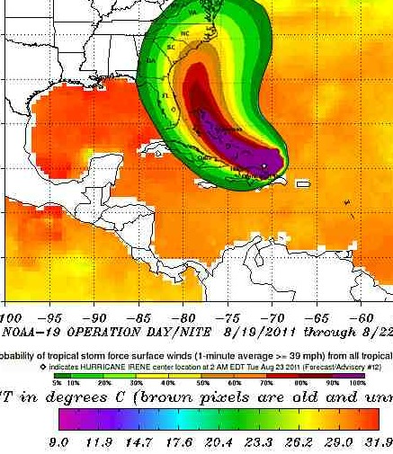
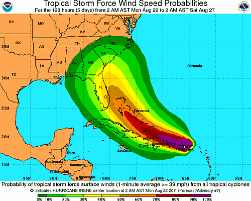
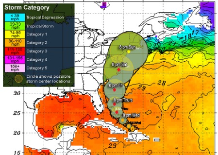
Track via NWS, ocean temperatures via NOAA, graphics DemFromCT. Click image for latest on Irene

Hurricane Irene intensified back to Category 2 status and may reach Category 3 today. The storm has broken away from island highlands farther to the south and now nothing but the Bahamas lays between Irene and warm water hurricane paradise. Irene could well reach Cat 4 strength over the next several days and make landfall as a powerful, deadly storm.

The track above superimposed over NOAA’s sea surface temperature data shows the forecast track as of early this morning. While the centerline has shifted ever so slightly east, there’s still a great deal of variability three or more days out, represented by the growing size of the circles. Irene is forecast to pose a major threat to North Carolina, especially the Outer Banks, eastern Virginia, and the Norfolk to DC region. If the storm follows the current forecast it skirts Delaware and wanders back out over water plenty warm enough to sustain or accelerate the convection cycle driving the cyclone. Irene could then go on to threaten the Long Island region right up through Maine as a hurricane or a tropical storm.

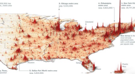
Population density in 3-d, derived from Time Magazine and the US Census

The diagram above, produced by Time magazine using US Census data, I think, shows why this track is such a potential disaster. A Cat 3 or 4 would be deadly wherever it hits, but even a weaker storm rolling up the east coast could rank among the costliest hurricanes of all times due to the sheer population density. If Irene were to strike parts of Massachusetts, New York, or Connecticut for example, and only do minor roof or wall damage to one home in 20, that’s still hundreds of thousands of  homes that will need a new roof. The same applies for signs, traffic lights, telephone poles, mobile homes, metal sheds, etc. The costs mount up fast.


I’ll have updated information including an intensity forecast throughout the day.

Twin double standard

Comparison of zygote development in identical and fraternal twins. Via the Wiki

Annie Laurie writing at Balloon Juice brings up an interesting point I hadn’t thought about, at least in this context. She spends the first part of the post briefly reviewing the rise in twin births and all the technology that makes multiple births possible these days, and then concludes with this FreeThought money graf:

And yet, all the hard science work and technological funding that lets modern mothers discuss the exact gestational age, sex, and probable birth weight of the “pre-born” babies whose ultrasound pictures they’re posting on Facebook is just invisible. Women gush that God has “blessed” them—or, in the NYTimes demographic, fret that perhaps they should consider fetal reduction, to “ensure” the most stress-free, high-resource outcome for a single precious survivor.

It reminds of a buddy I used to know. A routine test caught early stage lymphoma. Surgery and chemo stopped it in its tracks. He hasn’t had a problem since. His version is “Jesus saved me,” which he devoutly believes. Of course, when medical treatment tragically fails, it’s technology’s fault or the medical staff, even though consistency would suggest Jesus killed that person. And thar she blows! The double standard.

Climate researcher Michael Mann cleared, again

Paleoclimate record for last 1000 years by Mann et al

I know Mike Mann, one of the progenitors of the Hockey Stick shown above. I consider him a friend and one hell of an expert to run things past. So I was happy to see this:

Finding no “evidence of research misconduct,” the Arlington, Virginia-based National Science Foundation closed its inquiry into Mann, according to an Aug. 15 report from the inspector general for the U.S. agency. Pennsylvania State University, where Mann is a professor of meteorology, exonerated him in February of suppressing or falsifying data, deleting e- mails and misusing privileged information.

This all stemmed from a theft of emails at a UK climate research facility in the Fall of 2009. Industry funded skeptics and their sadly misled followers combed through thousands of emails looking for the conspiracy they’d been assured existed. When none was found, the scumbags picked a few out of context phrases and leaned on the powers that be with all the might of Fox News and their merry band of dipshit viewers to crucify the scientists anyway. Mann was caught up in that witch hunt. It was an ugly sight: the ignorant and superstitious having a go at brains and careful analysis.

Since then he and every other scientists has been found to have committed no fraud or conspiracy or anything like that by half a dozen different investigations. This is about number seven to follow suit, although I’m starting to lose count.

Dwarf planets may hold water and methane ice

A possible reconstruction of what OR-10 might look like. Source Wiki

The California Institute of Technology is reporting that half of the Dwarf Planet nicknamed Snow White is covered in water ice that may have flowed from ancient cryo-volcanoes and clad in a thin layer of frozen methane.

Discovered in 2007 orbiting the Sun at the edge of the solar system, Snow White, about half the size of Pluto, is the fifth largest dwarf planet. When first discovered by then graduate student Meg Schwamb, professor Mike Brown name the planet Snow White after its incorrectly presumed white color, but the dwarf planet is actually one of the reddest objects in the solar system.

Object 225088 also known as OR-10 is among the larger dwarves past Neptune, near the mass of Pluto, and currently the largest object in the solar system without a formal name. Alas, the discovery of the reddish color discredits the Snow White moniker. Dwarf planet hunter Mike Brown – interviewed here on Daily Kos — has suggested “Jerry.” Shown below is what Brown, the Killer of Pluto, proudly calls his “children” to date.

Dwarf planets discovered to date & shown to scale courtesy of NASA

Irene gaining steam, poses real threa to US east coast

NWS track and NOAA sea surface temperatures (19 Aug - 21 Aug). Click image for latest on Irene

Hurricane Irene reached Category 2 status yesterday and may see further intensification today. The current storm track profile is shown above super imposed on next NOAA’s latest sea surface temperature data. Irene is forecast to track over water in the 28° to 30° C range (84° to 86° F) all the way to North Carolina. A small deviation from the centerline to the north and east will bring Irene over the DC metro region in 28° to 29° C water, warm enough to sustain a major hurricane, Saturday to early Sunday.

Forecasting hurricane movement is not an exact science. Eyes wobble, collapse, recycle; five days translates to an average error of 250 miles. In this case, 250 miles means the difference between a major hurricane that makes landfall in Florida, SC and NC and/or buzzes up the east coast, to one that barely brushes the seaboard and curves harmlessly out to sea. It all depends on the magnitude and location of that projected turn off the coast of Florida. The latest premiminary data suggests Irene has slowed down a few miles per hour, and if that continues it could mean she will turn a few dozen miles sooner.

The latest intensity forecast models for Irene will be out shortly and I’ll try to update at that time.

Update 11 AM CDT: Via Jeff Masters:

Latest microwave data suggests that Irene does not have full eyewall; a gap exists in the south side. With wind shear now a moderate 10 – 20 knots, Irene may have trouble intensifying today. The hurricane is embedded in a large envelope of moisture, and wind shear is expected to remain moderate, 10 – 20 knots, for the next four days. With water temperatures very warm, 29 – 30°C, these conditions should allow for intensification to a Category 3 storm sometime in the next two days. Satellite loops show that Irene is steadily growing in size, which will protect the storm against major disruption by wind shear. The storm is lacking much development on its southwest side, where the presence of Hispaniola is interfering with development. Once Irene pulls away from Hispaniola tonight, intensification is more likely.

I’ll add, there’s damn near a fleet of aircraft and spacecraft now heading to and from this storm or watching it closely. We’ll have quite a bit of data coming in over the next 48 hours.

Irene takes a bead on Florida & east coast

Irene's projected track as of 8 AM CDT. Click image for latest NWS updates

If I had to second guess expert storm forecasters, I’d guess — and please not the word guess here — that this storm will curve a little more quickly east than the center track shows and miss the Florida peninsula. Maybe some rain and wind to Florida’s space coast up through Jacksonville. If it does that, it could easily barrel into the DC region. Imagine several million residents packed up in cars fleeing, roads congested, occasional breakdowns, kids standing on the side of the road. In fact we don’t have to imagine because that’s what happened in Houston a few years ago when Rita came to visit. So guys, if you’re in that area, have your plans made ahead of time and be ready to beat the rush.

But aside from my random guessing, here’s what the models say via Jeff Masters as of an hour or two ago:

The most popular solution among the models is to take Irene to the northwest through the Bahamas on Wednesday and Thursday, then into the Southeast U.S. coast in South Carolina or North Carolina on Saturday. Irene would then travel up the mid-Atlantic coast, arriving near Long Island, New York on Monday morning as a strong tropical storm or Category 1 hurricane. One of the models proposing this solution is our best model, the ECMWF. However, we have two other of our very good models suggesting a landfall near Miami on Thursday night is likely (the GFDL and UKMET models.) NHC forecaster Stacy Stewart gave some good reasons in this morning’s discussion to favor a track close to the east coast of Florida, but just offshore. Last years’ worst performing major the model, the NOGAPS, predicts that Irene will pass out to sea, missing the Southeast U.S. coast.

Science makes strange bedfellows

OK, when I wrote a few days ago that there wasn’t one idea offered by the Teaparty that hasn’t failed or won’t work, I was wrong. W-R-O-N-G. It turns out there’s an organization called Teaparty In Space that’s tracking government pork being divvied up under the disguise of NASA funding and who are enthusiastic about newspace. And they are indeed not the least bit afraid to call out Republicans who talk the talk but don’t walk the walk:

With Senator Kay (TX-R) Bailey Hutchison’s press release last week we now know the full roster of senators who are pushing for a $38 billion dollar “bailout earmark” or Space Launch System (SLS). Clearly, these same senators are not interested in fiscal responsibility, limited government, free markets, or an affordable space program for that matter.

Good for them! It’s a pretty spiffy looking site too. Why don’t progressives have something like this? I can sure think of someone who could run it for a most reasonable fee (Cough cough). The answer is progressives are always short on money. I keep waiting for my George Soros hate-America check, but so far it hasn’t shown up.

It’s nice to see this nascent movement on the right freaking side of an issue for once, especially a science issue. Hopefully, this one oasis of common sense and love of science will grow and affect the wider movement. Hey, a blogger can dream!

Libya may have a republic … if they can keep it

So went Ben Franklin’s famous line. I’m too lazy and rushed to look it up and see if it’s legit or part of the crazy history created by sociopaths to keep the gullible nut burgers in line. It applies either way, because Libya appears to be on the doorstep of national independence.

The vast majority of Libyans live on or near the coast

Libyan rebels swept into Tripoli and captured two of Qaddafi’s sons as the battle to end his 42 years of autocratic rule arrived at the doorstep of his presidential compound. President Barack Obama said Qaddafi must recognize he “no longer controls” Libya as celebrations broke out in Tripoli’s Green Square, the location for pro-government rallies in recent months.

Welcome Libyans, to the club of nations that had to fight and die to throw off a brutal tyrannical rule. You have very good company including Mexico, Philipines, Poland, France, Italy, and of course the United States, and well, pretty much most of the western world at one time or another.

Back when those 13 little colonies first got word the British were throwing in the towel, one of the first things they did was start feuding bitterly and enacting Sedition Laws. Congress argued so voraciously it sometimes came to blows. Factions arose, joined, splintered, and reformed. Eventually the nation almost blew apart in the Civil War.

Republics are not easy to keep. But Libya has a shot at one. Libya is not over-populated, they have high quality crude reserves already developed, they have a fertile coast and, for a desert nation, a surprising amount of arable land. They’re also tribal, local, heavily influenced by religion, of diverse origin, and in general organized more on the coastal city-states weakly controlling vast wild territories model than on a competent central government. Maybe I’m a hopeless romantic, but that sounds familiar doesn’t it?

Libya has a chance, the next year or two will be absolutely critical to what kind of nation they become. Right now hopes are high and the future uncertain. If the transitional government can indeed transition into an albeit messy but functional and growing government that greatly improves the lives of regular citizens, then NATO, the EU, and yes the Obama administration, will have out neocon’ed the PNAC neocons for about what Bush’s Iraq blunder cost in a single week, and without losing a single US service member.

Sinkholes on Mars

Taken by Mars Reconnaissance Orbiter in July 2011. Click for more.

Man that’s cool. It’s a sandpit on Mars that seems to lead to an underground cavern. Phil Plait has the scoop:

In the distant past, Mars was geologically active. Rivers of lava ran across the surface. If the surface of the lava hardens it can form a roof, allowing the lava underneath to continue flowing; these are called lava tubes and there are bazillions of them in Hawaii, for example. Eventually, the source of the lava chokes off and the lava flows away, leaving the empty tube underground. If the roof is thin in one spot it can collapse. Sometimes that just leaves a hole, but apparently in this case it was under a sand field. Some of the sand must have fallen into the chamber below and eventually blown away, leaving the pit and the hole. The pit is located not too far from Pavonis Mons, a known (long-dead) Martian volcano.

Mars was once thought to be dead as a doornail, geologically and biologically. The jury’s still out on the latter, but Mars does undergo a little more surface geology than some scientists initially thought. In addition to ancient lava tubes and occasional impacts, more modern superficial features rise and fall with the interaction of subsurface water, wind, and the planet’s wandering axis.

The earth is locked into a tight range of obliquity thanks to our largish moon, we’re currently tilted over at 23 1/2 degrees giving us seasons like the horrid summer we’re suffering through in Texas right now. Mars is pretty close to that mark, about 25 degrees, so it has earth-like seasons too. They just last almost twice as long because the Martian year is about 1.88 earth years. Mars even has a near 24 hour day!

But Mars lacks a large moon. Its obliquity could vary wildly over the course of several tens of millions of years, theoretically between zero and 180 degrees! That would mean Mars rolls on its side, one pole pointing to the sun for half its long year, the other in darkness. Water ice and maybe other substances build up where sunlight is scarce. Right now that means near the poles and inside craters in the shade provided by the rims. But all that changes if Mars keels over, the water sublimates away leaving spaces that collapse, it may even cause briny sandy muddy Mars-slides, and some of it relocates elsewhere causing frost heaving and other surface phenomena.

Come to think of it, an exposed lava tube would be a pretty good place for ice to congregate, and the walls would be easy to seal against the harsh Martian cold and lethally low pressures. Water, shelter, with sunlight and soil nearby … that sand pit and others like it could be the future home of real Martians, the kind who came by way of earth.

Is there room for science in the GOP?

Anyone who’s watched politics over the last few decades in America has seen a powerful shift in the Republican Party away from science (And sanity in general) in favor of rigid hard-right ideology and magical thinking. Jon Huntsman, former Utah governor and current long-shot GOP 2012 presidential contender, spoke out on that regrettable trend last week:

“When we take a position that isn’t willing to embrace evolution, when we take a position that basically runs counter to what 98 of 100 climate scientists have said, what the National Academy of Science has said about what is causing climate change and man’s contribution to it, I think we find ourselves on the wrong side of science, and, therefore, in a losing position,” Huntsman told ABC’s “This Week.”

It would be nice to see Huntsman do better, but among likely conservative primary voters he’s in the low single digits. I don’t think there’s room in the Teaparty run GOP for a candidate who recognizes basic science. That genie got loose, some might say it was intentionally let out and encouraged to roam wildly, and it ain’t going back in the bottle anytime soon.