Behold the majestic crag in all its glory! With a little surveying work, the highest point in Stevens County, Minnesota has been identified, at 45.745271 N, -95.830586 W, a dizzying 1272 ft above sea level.
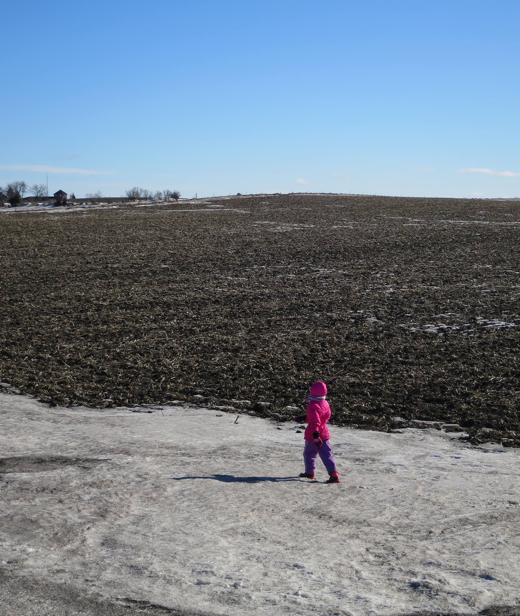
You see it, don’t you? And of course it’s covered with corn stubble.

Where is it exactly? About halfway up the hill?
If it makes you feel better, that’s about three times higher than our highest (continental) elevation. The highest point in all of the Netherlands is now on the isle of Saba in the Carribean.
What, it’s not at Glacial Lakes? I mean, those are actual hills.
Still, with sea-level rising, it’s good to know where to flee to.
Glacial Lakes is not part of Stevens County, so it doesn’t count.
Also, the mean altitude in this county must be about a thousand feet above sea level. I hope the oceans don’t rise that much! Derek is probably hoping even more that it doesn’t.
Indeed. Glacial Lakes is interesting, so the silly upstarts with not much up can feck off…
(Having now made an enemy of everyone in Stevens County — all three-and-one-half of them — what is the best way of recognizing a Stevens Countyite? Speaking “American”, unfamiliar with hills, breath of rotting fish soaked in lye(or whatever the local disgusting dish is), and…?)
Tsk, you rugged mountain folk showing off about your pinnacles. Our Glastonbury Tor – the only elevation you can see here on the Somerset Levels – is 521 feet tall. That’s a sensible size for topography. Any bigger and we’d have to start worshipping it as a god.
Oh, I thought the stubble was your mountains. I guess the stubble might raise your elevation another foot?
I get to sneer because I live in Ecuador now, and routinely traverse a pass between the volcanoes at 4200 meters (13,780 feet.)
negative 95.830586 West? What exactly does that mean?
@woozy #8:
Obviously, it means 95.830586 East, putting us somewhere in Outer Mongolia.
After summiting that peak, you’ll have to try your hand at Mt. Sunflower, the highest point in Kansas.
Beware, the south col is treacherous in the winter.
re @8:
let me try to answer your question, not being a cartographer so caveat emptor
I suspect the W designation is technically superfluous, that the negative sign indicates west of prime meridian (Greenwich, England) positive values in the eastward direction. With a max of 180 in the Pacific.
re 11
superfluous-> redundantThe highest point in Iowa is any hog lot on a warm summer day.
We’re totally spoiled with mountains here in the Salt Lake Valley, as you probably remember when you lived here. Tall mountains around us as far as the eye can see.
Oooh, look…I see there’s a glacier on the mountain. I also see that nearby is the Terre de Pomme River, which meanders through Morris, and the Terre de Pomme Lakes. Did they grow potatoes around Stevens county in the past?
All of my ancestry came from the region around Dusseldorf, Germany, shortly after the beginning of the 20th Century, and settled in central Missouri. I grew up on the farm that my maternal great great grandfather established over a century ago, in a town of ~260 people. We were/are Catholic (well, except for me and my siblings), which makes us the “alright” sort of immigrant lineage now, I guess.
Well, I suppose *I’m* not the right sort of American any more, since I decided to leave my country roots for my education, met a nice girl from communist China, got married, had a baby, and got a job with the Evil Federal Gov’t in one of those crime-ridden East Coast cities.
This immigrant ban has me worried not just on general moral principals, but over personal concerns as well. What happens if we decide to take a trip to China in the next 4 years to see visit family and Cheetoh Mussolini decides that he wants to ramp up the heat even more with that relationship and institutes a travel ban to that country? Or if my wife’s grandparents have further health difficulties – will her mother (who is staying with us and has a greed card) be able to come back to the US? Concerns that should be the sole territory of the tinfoil hat brigade are now, sadly, things that have to be given actual credence.
Ah, nuts, posted to the wrong thread… *blushes*
So, wich one of Lu-Tze’s famous bonsai mountains is this one?
@cartomancer #6:
I’ll see your Somerset Levels and lower you a Lincolnshire Fen. Where I grew up the highest natural point above sea level is nine feet, and technically it is the peak of an underground mud hill surrounded by salt marsh and alluvial plain. You’ve got to go 15 miles inland to find rock, and on Lincoln Edge they did decide to worship a god by sticking the 525ft Lincoln Cathedral on top of a 250ft elevation. For a few centuries after it was built the cathedral was the tallest man-made structure in the world, taller than the Great Pyramid of Giza.
Makes you wonder if the architect had tiny hands…
One of my professors had taken his PhD at Texas Tech, and had a poster much like this on his office door. It read, “Ski Lubbock.”
“Terre de pommes” would be “land of apples” — “pommes de terre” is potato, but in North America, “patate” is more common.
That was for robro@15.
Your etymology could be correct regardless, names get mangled.
Just lookiing at the photo gives me vertigo. Whooooooooooooo!
“Terre de pommes”
Oh missed that. I was willing to read that as terrre des pommes de terre but then I live in ONT.
I dunno, The Terror of Apple River sounds like if could be a Doctor Who story…
Wow – real mountains! Around here the highest elevation is 15 feet and 5 inches above MSL, and that’s the top of the levee.
Ooops…senior moment, posted in a hurry, blah blah blah. It’s “Pomme de Terre.”
After living in Louisiana for a number of years, I get dizzy at any altitude over 50 feet. :)
Actually, La. does have some fairly high hills in the northern central section. In south Louisiana, Baton Rouge is the first actually high ground you hit coming north from the Gulf of Mexico. The downtown, original city is 30-40 feet above the Miss. River. The land rises overall as you go north (it has low areas that flooded in the August heavy rain and in other heavy rains in the past) rising to the Tunica Hills before you reach the state of Miss. They’re more rolling country than hills, but the land continues rising going north. Western Mississippi is basically a plateau high above and between the Miss. and Pearl rivers.
I tossed in that bit of geography for people not familiar with this area who think much of it is swamp/marsh. A lot of it is, but it has higher ground as well. Anyway, I hope the people of Stevens County enjoy mountaineering in their area with all the equipment necessary for climbing such heights. :)
How does corn even grow at that altitude?
It doesn’t. That’s one of Joseph’s grain silos. You know, like the pyramids in Egypt.
That child must be enormous.
I’m sitting at 2800 ft. and if I stand up and crane my neck I can see the top of San Gorgonio Mountain at 11,500 ft.
As the taker of the picture, I would like to add that the family reviews of this trip included requests for extra oxygen, references to Dr Shivago, and votes of no-confidence that this really is the highest mountain in Stevens County.
I wonder if that’s where the Ark really came to rest???
Majestic!
I’m impressed. In my county, Bernalillo county, NM, we only have the 10,679′ Sandia Peak. You’ll have to put a tramway on it to get to the top like we did with our mountain.
Actually, my late father is from your area, Osakis in next door Douglas county. It’s a bit different from New Mexico.
What happens if the ground water level is high, and you need to dig a grave? I seem to recall the wealthy in New Orleans had trouble with that, and had to build their crypts to guarantee a dry inside.
And, do you have any impressive ice-age rocks that have been transported by the glaciers? One big glacial rock would tower over the landscape like the mountain where Smaug slept on his treasure.
Did anyone say “corn” ?
It begins…
” Corn turning French hamsters into deranged cannibals: research https://phys.org/news/2017-01-corn-french-hamsters-deranged-cannibals.html Lack of vitamin B3 is making the wildlife eat its own young.
I was very impressed that my son was biking all aound Brainerd (it’s one of the largest cities in central Minnesota! Wikipedia says so!), until I visited Brainerd.
Son: There’s actually more of a slope out by the college.
Me: I have walked to the college.
#4 / PZ – Well, we live in the center of Amsterdam on a canal, and we have the ground and first floor. French doors on the first floor and a boat. Worst comes to worst, we’ll just caulk the downstairs and take the boat everywhere…
One of the first winters I moved here (93/94 or 94/95, don’t remember which) we had MASSIVE flooding and some 10% of the population had to be evacuated. The problem was the interior waters – the rivers overflowed their dikes. We might get screwed by rising sea levels, but I think we’re probably the country best suited to deal with having to raise dikes and build floating houses and whatnot. In a sense, Dutch society was created in the middle ages by the necessity to build big dikes, have massive public works projects, and whatnot.