Using a paleobiology database, here’s a map of all the fossils that have been discovered in the US, of all sorts.
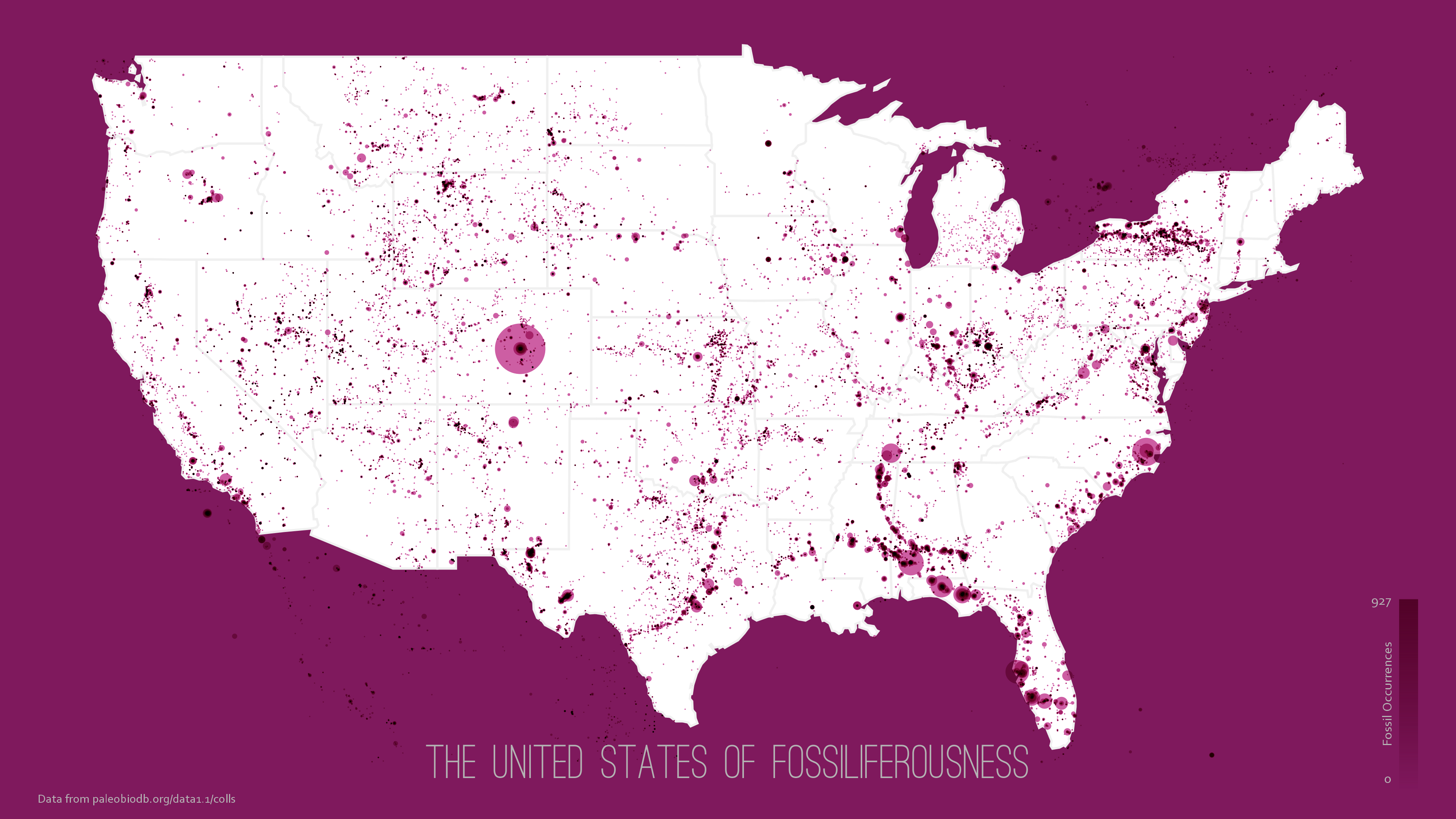
There are some patterns in there. The one that disappoints me, though, is that western Minnesota, where I live, seems to be a great wasteland for fossils.

It appears that fossils are afraid of me. Nothing close, close to nothing in CuttleState.
There’s been a decent amount of fossils found in my region-the Florida panhandle. Someone should tell Dr. Dino.
I’m surprised that Alabama seems quite fossiliferous.
Appears to be a gap her in Chiwaukee between the south end of Chicago, and some deposits over the border in Wisconsin. And I too, live in a gap.
Here is something fun.
Those are geologic maps of individual states. In each directory there is a link to two “kml” files that work with Google Earth to overlay the data on Google Earth (you only need one and the difference has to do with a browser version I think, I used the larger one and it’s fine). It’s interactive so you can click on regions and call up detailed information on strata.
I’m sure there are places to find fossils in Minnesota somewhere. Looks like Morris is surrounded by middle to early Archean strata so microfossils. Maybe Minnesota is just too old.
Obligatory song.
So did those glaciers scrape away all the fossils?
No, many of those fossils found in the Midwest are in lower layers from gravel pits. The top soil is sand/clay/glacial till, eskers, and morains. I have some nice trilobites from a pit in northern Ohio.
Areas like where PZ lives has been sea/shore/land/shore/sea many times.
I think that’s a misreading of the map legend. Soft-bodied cephalopod fossils show as white dots. There are so many in your area it looks like a blank spot compared to the rest of the map. You could go out into your back yard and dig a hole, when you’re over this latest medical excuse for just sitting around doing nothing. When you get a hole 4 foot in diameter by 4.5 foot deep if nothing is there that is the sure sign of a soft-bodied cephalopod fossil. You can then add another white dot to the map.
Neat, Kansas ain’t bad.
Not something I ususally get to say.
Next time you come to Germany you stop here for two days and we go fossil hunting. Since this used to be a mining area they have been dug up from a few thousand metres below the soil and piled up in a neat mountain. Though it’s mostly plant fossils, but my mum used to have a really nice big fern fossil my grandpa brought her from work. She gave it away, though, and not to us.
Perhaps because the fossils are all still walking around above ground? Ba-DUM-tisshh
I live in a void,
a void is nothingness,
you have reached Zen Nirvana.
I thought the migration of fossils from the upper Midwest to Florida was well-documented.
Ooh! I live in the big pimple of fossiliferousness!
Well, Michelle Bachman has a fossilized brain; does that count?
Nothing here in NE Georgia either. All I’ve got is precambrian/paleozoic rock and an abandoned gold mine. No sign of a precambrian bunny in the mine but I’ve still got some digging to do.
It is a sorrowful life living without fossils but consider that you are living on a corner of the Precambrian Shield, also known as the Canadian Shield, which precludes fossil finds but puts you on a bed of solid rock that is shared by us, the Canadians. You may claim these honours:
http://freethoughtblogs.com/pharyngula/2015/07/16/theyd-be-insufferable-if-they-werent-so-nice/#more-24729
An interesting map, but not complete. Stromatolities are common in some pre-Cambrian rocks, which don’t appear on this map. The map also appears to lack most of the isolated sites were Pleistocene fossils have been found. in addition, Phanerozoic fossils can be found in glacial drift in MN (ice scoured the Paleozoic rocks of the Hudson Bay Lowlands) – for example, its fairly easy to find fossils that have been transported 100’s of kms in Lake Superior beach rock.
The Red River basisn is covered in thick deposits of glacial drift, including Lake Agassiz sediment. Combined with a very low relief, there isn’t much outcrop. There is however fossil bearing Cretaceous shale in western MN ad easern Dakota. There should be outcrop not captured in this map on the western edge of the Red River basin where there is some relief.
While NY is in general pretty infested with fossils, central and western New York particularly, looking at the map you will see a line going across the state.
That’s the cut of the Erie Canal.
I grew up on a mostly-drained salt marsh. No fossils.
Come to Winona, we have fossils.
That just means that all the fossils are still waiting under the surface for you to dig them up, PZ!
Minnesota has lots of fossils, its just that the west side is also the bed of of a glacial lake that existed for thousands of years. The sediments are several hundred feet thick, and the landscape is remarkably flat. The line of fossils that angle across the corner is the Minnesota River valley, where you can find bedrock exposed on both sides of the valley created by glacial River Warren, as it carved itself a new route to the Mississippi.
The fossils in PZ’s area are Cretaceous age marine animals, including large to extremely large shelled cephalopods, sharks teeth, various clams and brachiopods, and one sea turtle. The top Cretaceous strata is a glacial till. So yes, the glaciers have removed large areas of bedrock and much of the fossil bearing rock of Minnesota multiple times. The southeast corner of the state remained ice free, and is known for its rivers, bluffs, and the best fossil hunting in the state. There the rock is mostly Ordovician and Cambrian in age, and it is extensively exposed and forms bluffs along the many rivers.
Those dots in the north above Lake Superior are Precambrian stromatolites which are dated at 2.1 billion years old. I commonly find pieces of this in glacial till. The stromatolites have been replaced with various iron silicates, so they are deep red columns of jasper in black dull magnetite or hematite. If you search for Mary Ellen Jasper you can see what it looks like both raw, and polished. The basement bedrock under the cretaceous rock under PZ’s feet is Archean. He lives on the Minnesota River Valley Terrane, which has been dated as some of the oldest rock in North America at 3422 Ma . It collided with Superior province during the Algoman orogeny, approx 2700 to 2500 Ma. The mountains have literally tumbled into the sea long eons ago, but the river still marks the boundary where they once existed. It truly boggles the mind to think that the rest of the Continent has gradually been added on over the intervening eons.
I live in Nashville. In most of Nashville, the bedrock is at most a few feet below the surface, and it’s all Ordovician limestone. You want half-billion year old shells? Check out any road cut, and you don’t have to look very hard to find natural outcroppings.
I’m wondering if the dearth of fossils in Western Minnesota could be due to the great ice sheets covering it during the ice ages? Mmmm?
Mmmm? Thanks Tethys, you helped with my question. I shoulda read it first before opening my big mouth!
Tethys, I would guess those dots north of Lake Superior are not stromatolites, but Cretaceous fossil localities (although I haven’t bothered to look at the database he used for this map). There are isolated pockets of marine Cretaceous rock on the iron range, including at Hill Annex State Park near Hibbing where fossil collecting is the main activity (gastropods, bivalves, shark teeth).
The Mary Ellen mine is in Biwabik, which I would place northeast of the few dots on the map, but the map is also missing a host of well known stromatolite loacalities – like the Kona dolomite in the UP and the Gunflint Fm stromatolites even farther north of the Iron Range.
The map could be improved if all the non-sedimentary bedrock was added.
andyb
Yes, there are also pockets of Cretaceous strata extending into the northern Iron Range section of the state. The eastern shore of Lake Agassiz fairly closely overlies the eastern shore of the Cretaceous age Western Interior Seaway. My point was that there are fossils in the Precambrian rocks. In fact, the banded iron formations themselves are technically a biogenic trace fossil, and some of them ( i.e. Vermillion Range) are found within volcanic strata due to the complex and extremely ancient nature of the local geology. I have long been fascinated with the atypical rocks of the Animikie basin, and the slightly younger but still extremely ancient Mid-Continent rift that extends from Michigan to Kansas.
The Mary Ellen jasper from the mine of the same name is simply a particularly pretty named semiprecious gemstone variety. The stromatolites themselves are preserved in a number of different iron silicate ( and in the case of the Kona mines, iron carbonate) minerals, and have a very extensive geographic distribution. Looking at the maps of the iron ranges found here , you will note that many of the fossil finds in central and northern MN are from former Iron mines. The Cayuna ranges are represented on the OP map, but the portion of the Arrowhead region that includes the Gunflint Range within MN is now mostly protected national park land. In addition to Stromatolites and BIFs, the gunflint chert also contains some of the oldest known microfossils.
Anywhere you find Superior lobe red glacial drift, you will find pieces of iron formation and stromatolites mixed in with the basalt and granite gravels; and also my usual quarry, our state gem, the Lake Superior Agate. /Minnesota geology geek :D
The original data can be viewed here: Paleobiology Database
I should have looked here first – it’s easy to use. The handy navigator appears to be funded by an NSF Geoinformatics grant to UW-Madison. Shanan Peters is one of the lead PIs – although he’s relatively young, he’s made a name for himself by focusing on big-picture paleobiology and quantifying the sedimentary record through time (what sediments are preserved through time and why).
There are very few Precambrian localities in the database, and none of the stromatolite localities mentioned above are are in the database (or that map). There are also errors, and the sites in the database are by no means exhaustive. [For example, there’s a Decorah shale site along the MN/ON (Canadian Shield), and the large dot SW of Mille Lacs, is on granite – rather than in the river valleys farther south. Whoever entered the data probably didn’t take the time to enter exact site coordinates.] There are a few Pleistocene sites (but those too are limited).
Despite the short comings, it’s worth taking a look. This is one of the reasons I like this blog – I never know what I’ll learn next.
Thanks for that link andyb. You are right that it is quite interesting, although it has multiple errors. It doesn’t show any of the Cambrian or Early Ordovician in Minnesota. I too am trying to figure out what the large dot SW of Mille Lacs might be, if it is not the stromatolites and BIF. AFAIK the fossil bearing sedimentary rocks found along the St. Croix and the upper Mississippi River Valley are truncated by glaciation north of the Twin Cities basin and west of the Mid continent rift. . I seem to recall a road construction through peat bog find of a large number of Giant Ground Sloths or other Ice Age megafauna sometime in the 80’s? I also seem to remember that there are some small areas of sedimentary rock around Little Falls, but my brain is old and cluttered so I may be remembering wrong.
I am not sure what you mean by this, as granite is found in both areas. The East-Central Minnesota batholith is a group of granites associated with the Penokean Orogeny. The sacred heart granite found along the Minnesota River valley is associated with the older Algoman Orogeny. There was a large asteroid impact nearby in between those mountain building periods that had some small effects too.
The prominent dot SW of Mille Lacs is just mislocated. The nice thing about the Paleobiology database is all the metadata associated with each locality pops up when clicked. The site is from a publication on Ordovician ostracodes in the Mississippi River valley – dozens of sites are noted in the report, but they’re all in the twin cities or downstream.
It’s funny how this map gets buzz online, but the actual database and user interface was not newsworthy.
The closest fossil to Morris in this online database is 35 miles away along Lake Traverse – Watinoceras coloradoense, a Cretaceous cephalopod (Cobban, 1983, Molluscan fossil record from the northeastern part of the Upper Cretaceous Seaway).
Poking around in some of the archives of the internet produced some records of fossils found while looking for viable lignite deposits along the Sauk River a few miles north of the city of Richmond, in prensent day Stearns County. Apparently they is a small area of lignite in clay and underlying shale that outcrops along the bank. I doubt these fossils are included in any modern databases, but I trust that the assessment given by Mr. Meek back in the late 1880’s is accurate.
Its from History of Stearns County and doesn’t have any other references to fossils.
blame the Glaciers from the last glacial max.
I’ve been exploring the database. It is an amazing tool, but it is very incomplete and as noted by andyb, many of the dots are completely misplaced on the map. Frinst, there is a large dot in east South Dakota that claims to be Cambrian trilobites. However, the Deadwood formation is way over in the Black Hills on the west side of the state, and there isn’t any Cambrian age strata in east south Dakota. The species list for my own locality, (early ordovician prairie du chein) only lists a few species of molluscs, but completely omits the fact that those fossils come out of a massive stromatolite/stromatoporoid/ calcimicrobial reef and doesn’t list a single echinoderm, the receptaculites, the brachiopods or the odd modular creatures that lived within crypt spaces in the reef. It doesn’t even bother to list the rugose horn coral, though admittedly it is very rare in comparison to the echinoderms.