For Suzanne

She made this possible:

View from the beach near Devil’s Churn


You see, a funny thing happened on the way down to Oregon.  We took the scenic route.  On that scenic route, there are many, many curves.  I’d driven through about 16,897 of them before Newton’s Law of Inertia caught up to us.  I learned a valuable lesson the hard way: no matter if you’ve gone nearly 20 years without doing something monumentally stupid behind the wheel, there’s always a first time.  Driving too fast on an unfamiliar curvy road definitely counts.  Thankfully, there were no other cars in the way and a nice dirt berm to stop us.  We had airbags to keep us from banging ourselves on hard bits that the seat belts may not have saved us from, and so I love them, even though those damned airbags deploying are probably the sole reason why my poor Nissan Sentra will be sent to the scrap heap rather than the body shop.  There’s not much damage – I wasn’t being suicidally stupid – but the insurance company tells me the airbags may end up costing more than the car.

So no shit, there we were, unharmed but stranded.  If it wasn’t for Suzanne coming to rescue us, we’d probably still be in a tiny town near the Oregon coast trying to figure out how to get to a city with an actual rental car agency.  She spent a good portion of her afternoon and evening fetching us and delivering us to a place with a hotel and a rental car, and acted like it was no big deal.  You can’t repay kindness like that.  All you can do is be there when huge favors need returning, and she knows I will be.

My intrepid companion took the whole thing with amazingly good grace.  I figured he’d want to head home immediately, but no, he was still up for adventure.  I have remarkable friends, you know that?

That all happened on day one.  By Day Two, we were off and running again, albeit taking curves about about 20 mph.  Grandmas look like speed demons compared to me these days.  We made it to Corvallis, where Lockwood showed us some of the finest geology I’ve ever seen.  He took us up a mountain and down to the sea.  We got to play in turbidites and tide pools.  I’ll be days just sorting through the pictures. 

(By the way, if you’re fortunate enough to have Lockwood invite you on a field trip, go.  You utterly will not regret it.)

More to come later.  For now, it’s time to catch up on sleep, cuddle the kitty, and reflect on the fact that I’m incredibly fortunate to have friends like these.

I owe all y’all not one, but many.

For Suzanne
{advertisement}

But Why Is the Geology Gone?

My intrepid companion and I made a valiant attempt to see the famous Flaming Geyser today.  The first thing that went wrong is that I forgot my camera.  That’s right.  Left it sitting right at home, and didn’t realize it until I arrived at my IC’s house, which is a bloody hour away from mine.

Needless to say, all photos that follow are courtesy of my IC’s camera.  Grr.  Argh.  (But I do have to say, while it’s no Sony Cyber-Shot, it did its utmost to fill in, and I adore it for that!)

The second thing that went wrong is this:


No, that’s not the Bubbling Geysers.  That, my darlings, is the Flaming Geyser.

Yep.

Flaming.


Yeah.  And, adding insult to injury, the route leading to the outcrops of Puget Group Shale and the actually-supposed-to-be-Bubbling Geyser, our only access to good geology in the entire fucking park – closed.  Fenced off.  Unsafe bridge.  No alternate route.


O-kay.  Take stock, here.  See what can be salvaged.  We found a few things.

Like, uh, yeah, an interesting leaf:


Yup.  That leaf sure is interesting.  Floating in the water there where the fucking Flaming Geyser should be.

I’m not sure what the hell happened to the park’s namesake.  The park’s website talks about upgrades and repairs and so forth, but not a single bloody word about the fact the Flaming Geyser’s drowned in a pool of water. Regardless, this famous little methane seep has a lot to tell us about Washington State’s geologic past, so let’s have a listen:

Allow me to translate: it’s saying that back in the Eocene, the coastline was right about where Puget Sound is now.  Back in them days, floodplains and deltas dumped sediment all over the Black Diamond-Auburn area.  And in the lovely subtropical climate, lots and lots of plants flourished.  Over time, sand and mud buried the flora, more flora grew, bury-grow-bury-grow etc.  Some squishy, some pressure, some crunchy faulting-and-folding, and voila – we have sandstones and shales complete with coal seams and pockets of natural gas.

The pocket that feeds the formerly-Flaming Geyser has been venting ever since 1911, when a gentleman prospecting for coal seams drilled down 1403 feet and got gas.  It used to be quite the sight – up to 15 feet high and 4 feet wide.  Now, alas, it is a shadow of its former self: when not drowned, it can manage a flame of around about a foot.

At least it’s still bubbling.  That’s something, even if it does remind me of cowboy bubble bath.

Alas, we didn’t get to see the shale outcrops, or the Bubbling Geysers caused by carbon dioxide gas, and we caught merely a glimpse of a nice cut in the sediments and till forming the hills around the park:


That’s it.  That’s all we got.  Couldn’t even look at the cliff to see what it’s made of, because there’s bloody Authorized Personnel Only signs everywhere over there.  Argh.

We decided to see if there was a back way on to the trail.  On our way, we discovered that Mother Nature has done some remodeling to the park.  She has, for instance, decided one of the picnic areas could do with a marsh:


And then we discovered an arm of the marsh sneaks up through the lawn, so you trap yourself in a sort of v-shaped area between a narrow marsh and a wide marsh and have to go round.  As we were walking that way, something jumped from beneath my feet.  Turned out to be the first actual frog I’ve seen in Washington State:


First time I’ve seen rather than merely heard these little bastards in three years of living here, and it’s the day when my camera, with its 10x zoom and its outstanding macro mode, has bloody well been forgotten at home.  There was Language spoken, my darlings.  Then I stuffed my IC’s camera back in his hands and decided that, if the camera couldn’t go to the frogs, the frogs could go to the camera.  Besides, I haven’t caught myself a frog since I was a kid.  I couldn’t resist.

The first one was relatively calm about the whole situation:


He sat with his dear little toes gripping my finger for quite a while.  Unfortunately, there wasn’t enough light for a good shot using my IC’s poor camera.  So most of the close-ups came out blurred.  And then my amphibian amigo decided the photo shoot was over and jumped away. 

Luckily, we found another, albeit more energetic, subject:


See his dear little toeses?!?  They’re covered with little grippy pads, and they feel slightly tacky on your fingers.  So cute!

So that was worthwhile.  Then we climbed a damned hill, and all we found was a single big glacial erratic buried in the till:


The rest of the geology was covered in biology.

Defeated, we headed for the Sound.  Hadn’t been to Redondo Beach since 2000, when Garrett and I visited the city and I fell in love.  We’d stumbled over this delightful little spot by sheer accident.  Well, my intrepid companion knows where it is.  We had sunshine and warmth, probably among the last we’ll get for the season, so we decided we’d better take advantage.

One of my fondest memories of Redondo is the huge granite arch there:


With the sun sinking in the west, you could see flakes of mica sparkling all over it:


And yes, that is a bright blue sky in Seattle.  It happens sometimes.

Of course, I had to play around a bit with it.  Took a shot through the arch with the granite in focus:


And one with the Sound in focus:


Because it’s fun, that’s why.

My intrepid companion caught me fondling the granite:


And this interesting little nodule:


Not sure what that is.  Ideas, anyone?

Got me feet wet in the Sound for the last time this summer.  My IC caught me picking up bits on the beach:


I found an absolutely marvelous bit of gneiss:


And a wee little crab:


Dead, alas, but still flexible, and morbidly cute.

Charles Darwin had his barnacles. So did I:


Found a chunk of them down on the beach.  I planned to take it home, but then some of the little buggers popped out trying to filter-feed, and so they stayed behind.  I’m not sure if they’ll find a place where they can survive or not, but it’s worth trying.

The back of them had a very intriguing pattern:


When I saw others encrusting the metal pilings holding up the sidewalk, all became clear: rust and paint.  I can only imagine the maintenance headaches these little buggers cause.

When we finished splashing about in the freezing-cold waves, we headed out on the boat dock for a nice long sit.  The water was an extraordinary blue:


When you’re looking out over that amazing azure sea, you’re gazing at a seascape carved by an ice sheet.  Hard to imagine on a warm day like today, but none of this scenery would exist in quite this way had it not been for 3,000 feet of ice.  Thanks, Canada!

This being the seaside, of course we had seagulls.  The fat brown juvenile stood at the end of the opposite dock and screamed for a while, at least until he found a friend.  Unfortunately, he proved why he hasn’t got many friends:


Afterward, he chased his very annoyed buddy down the dock with a desperate-to-be-loved expression.

We didn’t stay for the sunset, but Suzanne caught a lovely one tonight, so you’re all set in the sunset department.

And that’s pretty much it.  Not much geology, but a lovely day nonetheless.  I’m rather going to miss summer.  Good thing I still have a ton of stuff left over – dearest Karen, rest assured that no one shall be deprived of geological adventures this winter!  We’ll dream some summer dreams while the snow falls.  Okay, rain.  It’s usually rain, here.  Lots and lots of rain.  Which probably explains why putting the formerly-Flaming Geyser in a shallow, undrained pit was such a very silly idea….

(Tip o’ the shot glass to the Hiking Guide to Washington Geology, which provided the geologic info for Flaming Geyser State Park.  It’s not their fault the damned thing’s drowned.)

But Why Is the Geology Gone?

Macro Mania

My intrepid companion and I had planned to go see the Flaming Geyser on Tuesday, seeing as how I had the day off and all, but this is Seattle, and it’s the day after Labor Day we’re talking about.  We got rained out.  So he came up here instead, and when we got a brief break in the drizzle, we headed up North Creek for some fun and excitement.

I went a little nuts with the macro mode on my camera.  It’s nice to be able to photograph gneiss, f’rinstance:


This is a little chunk o’ rock in the stone wall by my house.  That’s one thing I love dearly about Seattle – all those glaciers dropped interesting rocks helter-skelter, and people pick them up and stick them willy-nilly in stone walls.  This is wedged in a sea of dark brown rock that’s welded tuff, as far as I can tell.  Still having trouble distinguishing some volcanics, alas.

Speaking of that possible tuff, you’ll see something really sweet if you follow me below the fold.


Isn’t that lovely?  Those little patches of agate and quartz are all over the place on these rocks.  It’s opportunistic stuff – if it can find an opening to settle in, it will, it seems.

That, alas, is all the geology I’ve got for ye today, but I’ve got some really lovely flowers, like this one:


Some sort o’ primrose, I believe.  Some of it’s still in bloom while the rest is already rosehips.  It’s a constant fascination how Seattle’s flowers tend to bloom at odd times.

Saw a line of oak trees, and acorns!


Broken green acorns are scattered all over the sidewalks by the ball field, and there’s tons more in the trees.  Looks like our squirrels won’t starve this winter.  Not that they ever will in this city.

Further down, it seems some local beavers are considering their land use options and possibly plumping for a pond:


Zoom in on that one, and you’ll see their buck tooth marks.  Further down the trail, they’ve done an even worse number on another tree:


Some of the trees along the creek sport wire mesh tubes.  Now I know why.

Saw this bit of mossy bark lying in the trail, and could not resist a closeup:


We’ve had rain for a few days, so everything’s getting bright green again.

Up by the restrooms, some wonderful white flowers are in full bloom:


I do believe that’s not native, but it’s still beautiful, and it smells divine.  No wonder butterflies like it.  Too bad it was too rainy for them.

Some of the clover’s blooming still, too:


That’ll keep the bees happy.  So will this, once the tiny little beetle gets his ass gone:


Berries are ripening all over the place, and when one’s very lucky, once can get more than one species in a single shot:


Most of Washington’s native berry species aren’t poisonous, but if you don’t know your stuff, you can’t be sure if you’re looking at one of the few outliers or possibly a deadly invasive, so we left the red berries alone.  We did, however, munch plenty of blackberries.  Trail food!

At a few places, the trail came close enough to marshes to give us good views of cattails:


I hear there’s good eating on one of those, but I’ve never tried one.

By the road, we found these lovely white-flowering bushes:


They seem to have more than one pollinator, or at least more than one critter who likes their blossoms.  There was this pretty green fly:


And then something that looked vaguely like a bee from a distance, but which turned out to be a wasp:


I didn’t even freak out.  This camera has changed my attitude to the insect world.  I don’t mind getting close enough to photograph wasps, and it turns out they don’t really care what I do when they’re eating as long as I don’t take their food away.  The wasps in this bush went about their business as if we weren’t even there.  We didn’t push our luck, however.

It’s definitely getting to be fall here:


Some of the trees are busy changing into their autumn colors, and a few have gotten a head start on the whole going dormant thing.

I’ll tell you a nifty thing about Sony Cyber-Shots with a Handheld Twilight mode: you can use in in daylight to get some pretty astonishing color:


That’s the same tree, but the red’s not as washed out.  I’ve used this trick on sunsets, too, and gotten results that are closer to what my eye’s seeing.

We visited a bit of the creek I haven’t been to for a good long while, and saw its rapids:


And there’s a new bridge near the freeway:


And, before the rains came, a white primrose:


Believe it or not, it was dusky and beginning to rain when I took that shot.  I think I’ve mentioned I love my camera, right?

We scrambled home before we could get completely soaked, and found a cat boxed up and waiting for us:


Doesn’t she just look the perfect angel?  Don’t believe it for a minute – you’re liable to lose a limb.

Macro Mania

Seward Park: A Scientific Wonderland

In Seattle, you take your sunshine where and when you can get it.  The weather reports all assured me we’d get rained on Sunday, but they lied.  I decided, on a whim and on a microscopic amount of sleep, that a trip to Seward Park was in order.  I’d just found out it had glacial erratics and an earthquake scarp, hadn’t I?

I ended up taking so many photos in just those few short hours that we’ll have to split them into groups.  Fault scarps and erratics shall have their own special post.  In this one, we’ll get an overview of some great glacial topography and some lovely sunshiny shots of life, the water, and other gorgeous things that caught my eye.

Allow me to whet your appetites with this image:


If you click to enlarge, and look to your right, you’ll see sun dappling the trees in a very satisfying way.  Then follow me after the jump for more.

Seward Park occupies Bailey Peninsula, which juts out into Lake Washington like a crooked finger.  It is (drumroll please) a drumlin.  You’re standing on a hill that didn’t exist until the great continental ice sheets came down, covered Seattle in 3,000 feet of ice, and left their mark all over the place.  Lake Washington was created by the same glaciation.  Believe it or not, while it’s huge, it’s a lot more shallow than Lake Crescent – only about 200 feet at its maximum.  What it’s not got in depth it makes up for in breadth – and its lovely shallows along the shore where you can see huge freshwater snail shells gathered up in tiny, quiet coves:


If I hadn’t had so much astounding geology to look at and so little time before we’d lose the sunshine, I might have lingered at that grassy bank with my feet in the water.  Maybe next summer, then.

The quieter areas of Lake Washington grow a copious amount of Nymphaea odorata, the fragrant water lily, which is incredibly beautiful but decidedly non-native.  Some of them are still in bloom right now:


And yes, that’s Seattle poking up in the background.  Could not, alas, find a place to get up-close and personal with the water lilies, so no macro shots of them.  Next summer, my darlings.  I know many good places where you can practically touch them.

They’d run out of maps, so I had to do a blind search for the fault scarp.  I headed up a side trail that turned out to go nowhere but right back to my car, but along the way, I saw a tree with amazingly fat roots poking up through glacial outwash:


I used to be incredibly confused by these deposits, so it’s worth taking a moment to discuss them.  All over Seattle, you’ll see these deposits on the tops of hills that look for all the world like a river dropped them.  There are well rounded pebbles and cobbles with the occasional odd large rock thrown in, all mixed up in a matrix of sand and clay.  And if you are ignorant of glacial landscapes, as I was, you’ll ask yourself, “How the fuck could a river run through this? It’s two or three hundred feet above the floodplain!”  Being from Arizona, I hadn’t had much experience with such things.

Turns out all that stuff is glacial outwash.  Before the leading edge of the ice sheet got here, meltwater from it poured out up to 400 feet worth of debris.  Ice sheets 3,000 feet in thickness can do such things with ease, especially when they block local drainage to the sea and cause lakes to back up.  I’m sure it dumped plenty more on its way back to Canada, and voila – we have river and lake deposits in some very odd places indeed.  They’re so thick, in fact, that you’re pretty much shit out of luck if you want to see bedrock in most of the Seattle area.  But there are a few places.  Seward Park is one:


This is a chunk of very coarse sandstone fallen from one of the fault scarps.  These (I’m reasonably sure) are rocks of the Blakeley Formation, about 26-37 million years old, and they tell a story of the days when Seattle was under the sea.  The early Cascade volcanoes erupted and eroded, streams dumped the results all over the continental shelf, et voila – a few million years later, bedrock.  Volcaniclastic, in fact.  (I love that word.  Don’t ask me why.)

Here’s another piece, which was too pretty to pass up:


‘Twas hard to tear myself away from the cliff, but blue water and bright sunshine beckoned, so I went wandering along a deserted strip of beach.  A very narrow deserted strip o’ beach, which was probably why it was deserted.  And I saw one of the biggest hollow logs I’ve ever seen in my life, casting its reflection into the water:


How lovely is that?

Along this strip, you’ve got a nice bank covered in trees, blackberry brambles, and other assorted plants shielding you from the main path, and a vista of Andrews Bay:


Note the wee waves: the wind was blowing predominately from the left, but you’ve got waves coming in from the larger lake, too, so you get this hatched, curved pattern.  Someday, I’ll know more about wave refraction and interference and all that, and I’ll be able to impress people with said knowledge (glazed eyes is a sign of interest, right?)  For now, though, we’ll just enjoy the lilies and the brilliant blue water and the glacial topography.

There were a bunch of purple flowers which I will someday be able to identify, all growing up through the blackberry brambles.  It’s late in the season, so some of them have dropped off and developed berries.  Here we have an example of both states of being:


One of the nicest things about Andrews Bay is that you get a good view of boats against a city backdrop with a little near-wilderness thrown in.  I know my intrepid companion likes that sort o’ thing, so these next two are for him since I abandoned his ass:


Regular flotilla, there.  When I came back this way as I was leaving, they had grills going and were wandering from boat-to-boat having a merry ol’ time, which is just as it should be on a holiday weekend. 

This boat caught my attention because it’s a bit atypical of what you normally see motoring around Lake Washington:


There are also excellent views of I90 from here.  It gleamed in the sun like a road from a sci-fi fantasy, and so of course I had to shoot it. Here it is headed into Seattle:


And to the east, crossing Mercer Island:


It looks surreal from here.  Sometimes, the things we build actually are beautiful.

Speaking of Mercer Island, here’s a good view of it from near the tip of the peninsula:


I learned just recently that it’s a drumlin.  Most of Seattle’s fabled hills are.  Ice is an amazing artist: it dumps its materials down, then shapes and molds and reshapes and remolds, moving things here and there, piling up masses of stuff in one area whilst gouging it away from others, never quite satisfied, until it gives the whole thing up as a bad job because it’s getting just too damned hot round here and melts back to happier climes.  I had only a dim idea of how powerful a sculptor it was.  Looking at Mercer Island, which gets up to 338 feet, one starts to realize that it’s not just volcanoes and continental collisions that can pile up a hell of a lot of land.

It has also made it a real bitch to travel on an east-west axis in this city, lemme tell ya.

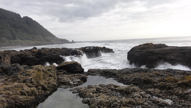
Here’s another good example of the power of water to change the landscape.  The waves curve around the point and come smashing into the shore, and you can see some pretty spectacular examples of sorting:


From right to left, you can see how the wave energy changes.  As water hits the shore and slows down, it’s dumped larger cobbles and angular fragments of rock.  Then there are the smaller but still large rounded bits of rock, grading into ever-smaller bits.  And you can walk the beach and tell just how strong the waves are and where they begin to lose their energy: everything’s sorted into great, long and very obvious strips grading from large to small, until you round the point and get to a lot of little pebbles that tell you things on this side are fairly calm.  You can see that at a lot of beaches, but this is the best example I’ve found here in Seattle in a very short stretch of beach.

There’s also a large grassy bank with some truly lovely blue flowers blooming in it:


Following the ever-narrowing rocky strip around the point brought me to another bank with plenty of blackberry brambles.  One of the things that’s always fascinated me about Seattle is how things grow here.  In Arizona, we haven’t got many blackberries, and where we do, they’ve bloomed, ripened, and are picked out by the end of June.  Here, they ripen late, and in areas with dappled sun, you can have new blooms with ripe berries right on top of each other:


And yes, they were incredibly tasty.  I got a wide selection from barely-ripe and delightfully tart to rich, sweet, melt-in-your-mouth goodness.  I don’t care that they’re invasives.  I loves me some Himalayan blackberries!

The “beach” becomes just a few inches wide a bit further along, and then you reach the end o’ the line, where if you want to get round the point, it’s either go back and get on the main trail, or get yourself soaked to the knee.  In that area, sheltered under an overhanging bank and a riot of plants, are some of the most extraordinary wave-carved rocks I’ve ever seen:


The blackberries prevented me from getting very intimate with them, so I’m not sure what that dark one with the blue base might be.  The whiter ones might be an extremely fine-grained and hard sandstone, or they might be limestone or dolomite.  I’m a bad field geologist – I didn’t have hydrochloric acid or even a vial of vinegar with me, so I couldn’t do the fizz test.  Never fear – next time I go to Seward Park, I’ll be prepared, and the mystery shall be solved.  There’s another bit of the same rock available a few feet back, out of the brambles, and it shall be duly interrogated.

Those boulders seem to be eroding out of the bank – judging from the sandy deposits in the lake bed here, I doubt the waves picked them up and moved them.  It’s pretty calm just there.  But they have managed to smooth the stones wonderfully.  It’s hard to see from the angles I was able to get, but those rocks have really been worked over.  They reminded me a bit of what I used to see in slot canyons.

Alas, I couldn’t linger.  Had to get home to call me best friend, get food and drink, and realize how very sadly out of shape I am.  On the way back, though, I had plenty of time to linger lovingly among fault scarps, and to admire yet more blue flowers, which it turns out can grow taller than I am.  And they love to pose:


Up by the Ampitheater where I’d parked, there’s a winding rock wall that begs for attention:


That’s at the top of one of the fault scarps, so I imagine they put those jagged stones on the top to discourage sitting.  It’s hard to see through all the plants that the ground just vanishes.  A person could step right over a cliff if they weren’t paying attention.

And here are our tax dollars hard at work hanging in a tree:


Entomologist were here!  The Washington Department of Agriculture is apparently doing a study.  Science happening before our very eyes!  I wonder how many park visitors don’t have a clue how important this sort of stuff is.  It makes me want to stand by random trees with green boxes in and give a quick and dirty field lesson in science.  So did the lifeguards at the beginning of the trail, who had no clue what a fault scarp is, or that they had one just a few hundred yards away.  When I retire, if the flesh is willing, I do believe I’m going to be spending the majority of my summers accosting people in parks and taking them on impromptu field trips.  This park especially is an open-air demonstration of several different branches of science all at once.  And I think people would enjoy that if they only knew.

Since you’ve been so good and made it to the end of the post, I’ll give you a sneak preview of the fault scarp:


You know, when I first moved to Washington state, I didn’t think I’d be getting much geology-wise.  A few volcanoes, yeah, and some plateau basalts, and that would be pretty much it.  When you come from a part of the country that displays in rather dramatic fashion over 1 billion years of geologic history all in one go, it’s hard to believe that a place as young as Washington would have all that much.  But I’ve discovered some pretty damned dramatic geology up here, all the way from spreading ridges to collisions between tectonic plates, from ancient sea floors to lands left by ice sheets, and from wave-cut cliffs to cliffs made by earthquakes.  Yes, it’s young land, but it hasn’t had a quiet youth.  And some of the most dramatic examples of the power of mother Earth to create and destroy are right in the middle of the city.

You really can’t ask for more.

For Seward Park geology, I commend this missive by Paul Talbert to your attention.  I wish every park had someone who would do up a page like this – it’s outstanding.  The Friends of Seward Park do a tremendous job keeping that park in order and interesting, and you can find a lot of information on many aspects of the park at their site.  This pdf from the Geological Society of America contains quite a bit of info on the area, including bits of Seward Park. 

Seward Park: A Scientific Wonderland

Outtakes at Last Vol. 2: Fog, Sun, Fog

Day Two: Wake up hideously early, realize intrepid companion isn’t going to be awake for hours.  No intertoobz due to wi-fi on the fritz in machine.  What else to do but head out for Hurricane Ridge Road to snap photos of all those lovely road cuts we didn’t get a chance to linger at the day before?

Port Angeles didn’t look promising.  Total gray from horizon to horizon and freezing fucking cold.  But the nice thing about mountains is that sometimes you can rise above all that, and you get to stand in the nice warm sunshine with an ocean o’ fog at your feet:


Bit o’ a delicate blush o’ sunrise, as well.

More below the fold, of course.

You already know the story of how I chanced into a lovely maternal scene.  This is for those who can’t get enough bebbes:


Not all of the wildlife is so gentle and lovable:


I did not see a single goat, aggressive or otherwise.  But I did see a rather charming waterfall:


Notice the slope.  These falls spill over sedimentary rock, which isn’t hard enough here to resist erosion and form dramatic cliffs.

After two warm and wonderful hours photographing geology and wildlife in the sunshine, it was back to Port Angeles, where the freezing fog hadn’t quite lifted:


Don’t be deceived by the bright blue water.  Yes, the sun’s shining, but there’s a fog bank behind the ships, and the sea breeze can only be described as “freezing fucking cold.”

Luckily, it was back to the mountains for us.  We headed up the Elwha River Valley, which is going to be a rather different place after this year.  They’re taking out the dams, so of course we had to go see ’em before they’re gone.  Feast your eyes upon this peaceful little lake, because it won’t be there for long:


That is Lake Mills, and here we have Glines Canyon Dam:


There’s a dirty great chain link fence all round it, so it’s hard to get good shots.  But you can see water spilling over the penstock – they’ll drain the lake by 80 feet, and then start removing the dam bit by bit, starting with the top bits you see here:


… and then removing further bits in stages until they can safely blow the remaining stump to smithereens.

Now, you may be saying, “But Dana, there’s two dams on the Elwha River!”  And so there are.  But we didn’t read the map properly, and so never found the other one, which is on the other side of Hwy. 101. Of course, we can probably get up there to see it next year, before it’s obliterated.  Even if not, well, we saw this one.

I’m rather looking forward to going back up after the lake’s drained, because I’ve got a hankering to study the sediments left behind.  Hopefully, they’ll allow visitors during this process.

While we were up by the lake, we saw lots of white butterflies all fluttering around, and whilst my intrepid companion amused himself with the dam, I spent my time trying to photograph the little buggers with their wings open.  Unfortunately, they landed too briefly and had a horrible habit of folding their wings up in those instants where they were holding still.  Then I found an easy target – one had fallen on its back in a puddle.  So I rescued him:


He spent some time drying out on my fingers before fluttering away.  His wings were a bit chewed up and missing quite a lot of scales, but at least he didn’t die an ignominious death in a mud puddle.

A little bit later, I found another butterfly just hanging about in the bushes.  I lurked around him for a bit, waiting for the instant when he’d fly away and I could capture him on the wing.  He refused to cooperate.  So I waved my hand near him by way of encouragement.  He wasn’t encouraged.  So I decided to see how close he’d let me get:


He wasn’t impressed.  Apparently, I represented a threat level of -10.  He just lingered there long enough for my hand to get tired, and just when I wasn’t prepared to press the shutter, the little bugger took off.  I never did get an action shot.  But it’ll do.

Once we’d been defeated by butterflies, we were on to Lake Crescent, which turned out to be one of the most delightful stops of the trips.  Warm sunshine, cold blue water, and a windsurfer close enough to touch:


The lake’s large enough for sailboats, too.  Cujo’s got the shot I took of ye itty bitty boat against the great big mountains.  Here’s one of it as it came closer, and I zoomed in a bit for a good view:


After lingering a while at the Log Cabin Resort, we made our way back up the road, stopping where the trees thinned enough for magnificent views.  Here’s one that shows the fjord-like qualities of Lake Crescent:


I could spend the rest of my life there, and wish for a few lifetimes more.  I mean, look at the color of this water:


See that wonderful emerald green there in the shallows, shading into sapphire?  I love it.  This is a perfect gem of a lake, and I’m glad it’s protected by Olympic National Park.

Uno mas.  We stopped at a beach along Hwy. 101, and got a view of the back side o’ the mountains:


Go through that fjord-like gap, there, and you’ll be in that peaceful arm of the lake we’d just visited. 

Further on, we found yet another pullout, which we stopped at because it had informational signs.  We spent quite a bit of time here, too, since the beach was littered with the most perfect skipping stones I’ve ever seen, and some very interesting rocks I haven’t yet identified, all down by this highway bridge: 


Again, note the brilliant color of the water.  I’d show you the rocks, but my photograph of one of the boulders is meh.  It couldn’t capture the extraordinary greens and reds, and the chalky streaks.  I’ve got samples here at home, so I’ll get them figured out eventually, and tell you all about them in a future post.

After Lake Crescent, we headed down through Forks (which is pouncing way too hard on the fact bits of the Twilight movies were filmed around there) on our way to the beach.  We’d meant to hit Ruby Beach this trip, but partway down the road to it, we saw ominous clouds and unmistakable signs of rain.  Well, if the weather was going to be that way, we weren’t going to go well out of our way.  Ruby Beach is right on the highway, on our way home, and so we stopped there.  It wasn’t any less cold and cloudy, complete with a light misty rain, but that was okay.  The incoming tide made enough of a splash to make up for it:


I can’t decide which to use, so you’re getting both of mah favorites:


You know, I could spend a lifetime here, too, and never get bored.  There’s all sorts of interesting things on a beach, like enormous clusters of shellfish:


And a sentinel of a sea stack watching over all:


No brilliant sunset colors that day, but they weren’t needed.  Not this time.

I’m lucky to live in one of the most changeable, varied, and astonishingly beautiful places in these United States.  Now if only I could get you all out here for a visit…

Outtakes at Last Vol. 2: Fog, Sun, Fog

Outtakes At Last Vol. 1: Hurricane Ridge or Bust

Yeah, yeah, I know the trip was over a week ago.  Yeah, it took me this long to pull out the bits I’ve decided you can’t live without.  I’m one of those horribly disorganized people whose time management skills are not the envy of all.  More like a laughingstock.  Besides, I’ve been busy pre-writing stuff so you won’t be deprived during the winter fiction-writing season.

But I finally got bits sorted.  Images lovely or otherwise below the fold.

For a while, there, it looked like the trip would be bust.  We here in the western Northwest live surrounded by water, which means drawbridges, which means getting stuck waiting at said drawbridge every once in a while.  At least I finally got to see how one works:


It doesn’t rise up as far as I’d expected.  But still, seeing the road bed rise up in the air is pretty interesting – for a brief amount of time.  Alas, this stop wasn’t brief.  At least the weather was pretty, the sea breeze fine, and we got to inspect Hood Canal up close.

Despite the name, Hood Canal isn’t a canal.  It’s a fjord.  We’ll be discussing it in a future post when I’ve gathered enough photos and info for a post on how the Ice Age made Puget Sound.  At least now you know where to go if you’re in the area and pining for the fjords.

We did eventually make it to Hurricane Ridge.  See?  It says so right here:


That’s part of a very large relief map at the Hurricane Ridge Visitor’s Center.  Relief is right – there’s a lot of up and down in the Olympics.

There’s even a mountain with my name on it:


That lovely triangular peak is Mt. Dana, a middling-high peak at 6,209 feet.  For comparison’s sake, Mt. Olympus busts clouds at nearly 8,000 feet, and Hurricane Hill is a piddly 5,757.  Course, the mountains are still growing, so who knows where my mountain will be in another million years or so?

There are incredible views from the Visitor’s Center, but of course the whole reason for being up there was to get out on the trails.  And there are some wonderful ones very close, which are easy walks even for those who aren’t up for much walking.  We took the Cirque Rim Trail, and got to see some wonderful features of the landscape without raising much of a sweat.

Here’s one of those things that continually astonishes people from Arizona – snow that hasn’t even finished melting by August:


We’re not far from having glaciers up at Hurricane Ridge again – cool the planet by a few degrees, and walking on warm dry ground in the summer may become a thing of the past.  Of course, chances of that happening anytime soon are remote – we’re more likely to be talking about the days when glaciers used to live in them thar hills.

I got a kick out of this building.  I’m not quite sure why.


Oh, what, you wanted mountains?  Fine.  Look down upon the Visitor’s Center, and out at what plate tectonics hath wrought:


Note the crumbly hillside below the road.  These slopes look solid, but they’re prone to failure.  Bits of them go slip-sliding away on a fairly regular basis.

Late July and August are when the wildflowers bloom in force up here.  And the Visitor’s Center has a lovely large meadow where you can get your fill of alpine scenery:


And butterflies.  But I’m holding those back for my own nefarious purposes – a post on Northwest butterflies. 

After getting our fill of the easy paths, we tackled Hurricane Hill.  And here’s how immersed in the geology I was: I was so enthralled by a particularly tasty outcrop that it took me forever to hear my intrepid companion hissing, “Behind you!”  I turned around, not a moment too soon, because a doe was practically sideswiping my butt:


She completely ignored us.  I probably could’ve stretched out a hand to touch her, but by the time I’d snapped off a picture, she’d crossed the ridge and disappeared into the cirque below.  Those little buggers can hide themselves in very little cover, I’m here to tell you.

Both the moon and the sun beamed down on us the entire walk.  Here’s the moon peeking over the sandstone shoulders of the mountains:


How gorgeous is that, eh?

Up on Hurricane Hill, there’s a lovely little tarn fed by late snowmelt, and a hillside of heather:


Okay, so that’s not the best-framed shot in the universe, but I was standing in the middle of mosquito central just then, and I wasn’t taking care to aim at anything but them.

After fleeing ye olde mosquitoes, we came to a calmer part of the trail, where we could appreciate the blush of the setting sun on snow-covered peaks with the glow of the moon above them:


And I could take a slightly-more relaxed photo of the tarn:


And here are the three M’s of any highland hike: moon, mountains, meadow:


You can, y’know, kinda click on the picture so the moon’s not a mere speck.

The sun slipped behind the mountains:


And so endeth day one.  Much more to come, my darlings.

Outtakes At Last Vol. 1: Hurricane Ridge or Bust

Some Preliminary Geological Findings

There’s rain in our forecast for the weekend, which means I can probably forgo further adventures in favor of catching up on some of my geology homework.  I mean, we haven’t even gotten to hug Oregon geology yet, not to mention all the other stuff in the queue.  And there’s outtakes from this trip to select and share.

Let’s get a bit of a jump on things, then, shall we?  We’ll combine a few outtakes with a desultory bit of geology, beginning with moi standing on the rim of a cirque:


There’s also a baby cirque (or possibly a landslide scar) just over my left shoulder, there, and Hurricane Hill right beyond.  I love the West!  Where else in America would an elevation of 5,757 feet be considered a hill

So anyway, no shit, there we were, standing right on the lip of a cirque.  It was too big to get all in one shot until we were well along the trail up to Hurricane Hill later on.  Here it is:

Glacier’s long-gone, but snow still persists late into the year in one tiny portion of the cirque.  Cool off the climate by a few degrees, and a glacier might grow there again, deepening and widening the cirque, and carving Hurricane Ridge into ever-sharper relief.  For those who are curious, the Cirque Rim Trail runs right long the top by the snow patch, there.

Along the trail, you can get an excellent look at very slightly metamorphosed turbidites:


If you think these rocks look like they’ve had a rough life, you are so right.  They started out as submarine avalanches.  Then, after they’d settled down from that excitement, they got stuffed 10-15 miles down into the subduction zone along the North American plate, folded, spindled, mutilated, and then spat onto the edge of the continent before being hoisted aloft, where they were promptly (geologically speaking) attacked by glaciers.  And they didn’t even get the compensation prize of becoming fully metamorphic after all that trauma. They still look pretty much like plain ol’ sandstone and shale.  But give them the dignity of calling them semi-schist and argillite.  They deserve some acknowledgment of all they’ve been through.

Time now to get off the hill (hee, hill) and descend to nearer sea level, whereupon one can stand knee-deep in Lake Crescent, which was carved by the Cordilleran Ice Sheet:


Now, the fact that this is an Ice Age-created lake that is 624 feet deep, blue as can be, and has scenery that might put one in mind of fjords is awesome enough, but you don’t have to take my word that it’s a glacially-carved lake.  You can just look at the evidence at your feet:


Water has done a bit of smoothing, and wave action has created potholes, but you can see the enormous parallel scratches.  Here’s a better look:


Those gouges were so straight, the resistant, saw-toothed strata so regular, that at first I thought it was the remnant of an old boat ramp or some such human-created artifact.  It looks fake at first glance.  I really wasn’t prepared for the immensity and power of what an ice sheet as opposed to a valley glacier can do.  It took close inspection, and noting that the strata disappeared under the bank, but eventually I realized that yes, that really is the result of a ginormous sheet of ice planing everything down to the bedrock, and then grinding the bedrock itself down.  Amazing things, ice sheets.

Late that afternoon, we made it down the coast to Ruby Beach, where you can see additional evidence of what water, this time in liquid form, can carve:


And yes, rumors of a sunny day at the beach were greatly exaggerated by the National Weather Service.  Bloody north Pacific storm systems.  But the cold, misty gloom didn’t prevent us from enjoying the lovely sea stacks, which here are easily accessible even when the tide’s coming in.  You all got plenty of exposure to sea stacks when we were kicking around Ecola State Park a while back, but these are special – they’re not basalt, but sandstone.  Here’s a good closeup of it that would’ve been even better if I hadn’t managed to change the camera to the lowest quality picture setting by accident and without noticing:


See?  Sandstone!  I found that fairly awesome.  Did a double-take when I realized I wasn’t looking at basalt.  Even more exciting: I have finally touched undisputed graywacke

Yes, I get excited over rather odd things.

Abbey Island, on the other hand, is composed mostly of mixed volcanic breccia and sedimentary rock, cooked into a hard whole by heat and pressure, with a healthy coating of sand and gravel on top:


We’re talking about a rather dramatic change in rock types in a matter of a few hundred feet.  This is definitely an interesting suite o’ rocks, and I shall enjoy delving deeper into their history for ye olde upcoming in-depth post on ye geology of Olympic National Park.  Which I shall have to you sometime in winter, after we’ve caught up with Oregon and Eastern Washington.

And everybody raise a glass to my long-suffering intrepid companion, who braved mosquitoes and freezing cold without a jacket in order to act as my personal photographer.  Then he did all the driving on the way back, without complaining, even when the CD player crapped out and I dozed off.  There should be a medal of valor for all that, not to mention endurance medals for all of you who’ve waited so patiently for me to get around to posting something of substance.

Some Preliminary Geological Findings

Fortune Favors Those Who Haul Their Asses Up a Mountain at Six in the Morning

I’m still recovering from the trip, still playing catch-up, and had to work Wednesday, which means eight hours of chaos.  Haven’t had time to sift through the 1000+ photos to find you the really good bits, and you know the geology’s gonna be a while.  That’s okay.  We have a long winter ahead.

In the meantime, I’ll throw out another teaser.  This one’s from Tuesday morning, when I got up insanely early and ducked out on my still-sleeping intrepid companion.  I drove up Hurricane Ridge Road to photograph all the strata I hadn’t had time to catch the day before.  I wasn’t expecting wildlife, and figured if I did see some, it would be at an inconvenient moment with no handy turn-outs.

How wrong I was:


Yes, that is a doe and her fawn, hanging out in plain view, right where I could park the car and photograph them. 

I can tell you that this trip was totally worth the sleep deprivation.  I can also tell you that I have done my part to ensure the birds on top of Hurricane Hill end up fat and happy.  No, I didn’t feed them – directly.  But, thanks to the fact we forgot the bug repellent in the car, and did not realize this glaring omission until we were over a mile away from it, I did feed quite a few mosquitoes, who in turn will end up in some bird’s belly.  This being-at-one-with-nature stuff is an itchy proposition, especially when you’re unable to swat nature away because you’re photographing other bits of it.

Now if you’ll excuse me, I must go apply more anti-itch creme and try to get a bit more sleep.

Fortune Favors Those Who Haul Their Asses Up a Mountain at Six in the Morning

Home Sweet Home

And now that I’m home safe, I’m going to indulge in immediate collapse.  But I wanted you all to have a little something:


Yup, that’s sunset from the Hurricane Hill Trail in the Olympic Mountains, that is.

So much to show and tell you about, once I’ve repaid my sleep debt.  I love you, and I’ve missed you, and I’m glad to be back home!

Home Sweet Home

A Walk in the Volcanic Clouds

I won’t have the geology from our trip to Mount Rainier up for a while – I’m still trying to catch up on Oregon and Grand Coulee, not to mention Arizona (and it’s been over a year since that!).  Haven’t done the research and am still scratching me head over a lot of the things I saw.  But that doesn’t mean you don’t get to vacation vicariously with me. 

We came in on the Mather Memorial Parkway, which was named in honor of the first director of the National Park Service.  There’s a wonderful little pullout by the White River that claims to give even more wonderful views of Mount Rainier.  This might be true.  However, most of what we could see in the distance consisted of clouds and trees.  Well, there was the White River, too, and a lovely little cascade of a waterfall:


I believe that’s andesite it’s tumbling over, but don’t hold me to it.

We played about in the river bed for a bit, where I got some absolutely marvelous photos that will delightfully illustrate future missives on mudflows and glaciers.  For now, though, I’ll just present you with this outtake of a few brave purple flowers growing in the volcanic mud:


If you look, you’ll notice a few bloom pressed down in the mud.  Plunk some more sediment over them, give them a few million years, and we may very well have glorious fossilized flowers.  This is, after all, how fossils are born.

For most of the day, Mount Rainier played peek-a-boo.  Here, we found it peeking on the Glacier Basin Trail:


You know, until you’re up on its flanks, you don’t really understand just how gargantuan it is.  The thing’s 14,411 feet in elevation.  It’s enormous.  Lot of lava, pyroclastic flows, and other assorted stuff went in to making it.  You get a sense of its mass when you’re up there.  And yet, all that bulk was built up in a mere geologic eyeblink – its oldest lava flows are less than a million years old, and its current cone is only half a million years old.  It’s still just a baby.  Amazing how good Mother Earth can create something of such magnitude so rapidly – and tear it down almost as fast.

Mount Rainier wasn’t the only thing engaging in some hide-and-seek.  We came across a waterfall along the trail that flowed under a root system that had its own ecosystem growing up on it:


That, I have to tell you, is quite a sight to see when you’re from dry country, where the root systems don’t usually collect enough soil and other such things to allow plant growth right on top of them.  Not to mention, we don’t often get water flowing anywhere

When we found out the moraine trail had washed out and never been rebuilt, we turned back around and headed for the hot springs.  If we couldn’t get cold, we’d get hot, damn it!  And we did – the first I’ve ever seen:


Those mounds behind me are dripping warm water.  Beside the trail, there are tiny pools of it that feel like a tepid bath.  They’re host to big fuzzy slimy mats of bacteria, which I couldn’t resist touching.  They feel slightly gritty.  Strange and delightful.

Afterward, we were onward and upward, heading for Paradise.  We’d hoped to see the Nisqually Glacier, but the cloud ceiling had gotten terribly low, and so we had no chance.  But I did get to see what the trail looked like when it wasn’t several feet deep in snow, and the stairs they’ve put in are gorgeous:


I love the architect who designed these!

Now, I’ve grown used to verdant green (somewhat – I still feel as if I’m being smothered by over-enthusiastic trees in the springtime), but I’ve never seen anything quite so vivid as those high mountain meadows.  If you’ve never been to an alpine forest in a place with heavy precipitation, you don’t realize just how different it is from the ordinary run of things.  It’s hard to explain.  It’s a serene green, a green of deep and subtle contrasts, and it feels so quiet.  It somehow manages to seem young and very, very ancient at the same time.  There’s a sense that time here isn’t the same time we’re used to.  This is the time of mountains and forests, of wilderness and things that will never be tamed by mankind.  It’s kindly, tolerating our presence with an amiable cheer, and you get the sense of it unfolding to let you settle in beside it.  This springlike summer won’t last; soon, the snowfields will return, and everything will be sharp white and cold.  But for now, there are green growing things and fields of flowers painting the slopes under the mountain mists:


No wonder John Muir called it “the most extravagantly beautiful” garden he’d ever seen.  It truly is that.

We stopped at an overlook – Inspiration Point, I believe – that gazes down into the Paradise River valley, and found ourselves taunted by a Stellar’s Jay who finally posed prettily for a photo op:


We headed down to Reflection Lakes next, where it rained on us a bit (rain in Washington, astounding, right?).  We took shelter under the trees and spent some quality time with lovely little flowers that a sign had marked as snowdrops, but upon further reflection (ha ha I iz funny) I believe are actually avalanche lilies:


There was just something about these quiet little flowers basking in the rain that delights.  Alas, the last time I was up there, they were buried under several feet of snow still, so I’d had no idea they existed.

The rain slacked off by the time we reached a rather stunning stretch of road clinging to the cliffs.  There’s a pullout happily placed where rockhounds can go and play in the rocks, but it’s mostly there for the waterfall:


That is Martha Falls, and it drops 665 feet down Stevens Canyon, plunges into Unicorn Creek, and shall feature heavily in some geological stories when I’ve had the opportunity to tell them.  For now, though, just stand back and admire the vista, because that picture above is just a wee bit o’ Martha Falls:


Stevens Canyon is one among many places we could have lingered all day.  We spent close to an hour there, but I didn’t have my eyes on waterfalls most of the time.  No, I was busy on the other side of the road, exploring lava flows and what I’d swear is granite, and generally having the time of my young life playing with the rocks.  My intrepid companion was kind enough to take a group photo:


The only thing that tore me away from the rocks was a rainbow, which started out dim and shimmery but grand.  We’d missed our chance to photograph a rainbow earlier in the day, so this was redemption.  And as the sun dropped below the cloud ceiling, it got brighter and brighter and then became a double:


It’s faint, but you can see it.  And it is glorious.  I now have about 40,000 photos of rainbows, so if you ever need one, do let me know.

We finally tore ourselves away from Stevens Canyon because there was a raw nekkid tunnel through lava that we wanted to reach before the sun set.  We got there in time, got some phenomenal shots which I shall share with you when I’m babbling about lava and engineering one o’ these days.  We even took video so we could record the excellent echo.  I left my intrepid companion investigating that marvel, and walked through the tunnel to a pull-out by the Box Canyon of the Cowlitz to see what all the fuss was about.  We’d seen it earlier, and figured a crack in the ground wouldn’t be a show-stopper.

How very wrong we were:


Y’see, when you’re standing on the bridge looking down into that crack, you realize just how very deep it is – over 100 feet straight down.  And the rocks are polished a bright, shiny black from Muddy Fork of the Cowlitz River, which is carrying glacial sediments.  It comes very close to putting Arizona’s celebrated slot canyons to shame.  Then I meandered over to the informational sign, and discovered there’s a half-mile loop trail that takes you on a foot bridge right over the thing.  You can look down 115 feet and watch the water work its will:


This is where 10x optical zoom and a nifty Handheld Twilight mode really come in handy, because by then it was very nearly dark, and, as I’ve mentioned, we were 115 feet above the bottom of the canyon.  Magnificent!

But that’s not all!  See the rounded rock on the left?  That’s rock that’s been smoothed and scoured by a glacier, that is, and the trail takes you right past bare patches where you can see the scratches gouged in bedrock.  You can even touch it!  I’ve never seen glacial features like this before.  Kid in a candy store doesn’t even begin to describe my reaction.  And here I thought I wasn’t going to get anything good for my eventual post on glaciers!

The other side of the loop trail goes through forest, where the trees have taken back what the glacier took away.  We wandered through in the deep, sylvan twilight, and as it had just rained, the big leaves of the understory plants were coated in silvery drops that proved no problem for Handheld Twilight to capture:


Dang, I love this camera!

We crossed the road after to see the Wayside Exhibit, which after the Box Canyon we figured must be something important, although it was awfully quiet about what, exactly, it was exhibiting.  Turns out that what they’ve got there is another huge slab of glacier-polished rock, and this time no pesky stay-on-the-trail rules:


Actually, I’m lounging, but close enough:


Moments like this, my darlings, are why all the boring bits of life are worth the trouble. 

We watched a good part of the sun set over the Box Canyon of the Cowlitz, and figured this was the end of the adventure:


Light all gone.  Time to go home.  We got back in the car and drove down the mountain, until we glimpsed a flash of blazing red through the trees and realized the mountain was staging one final goodbye show.  One last stop, then.  You’ve already seen the results of that.

For a day that looked like it wasn’t going to return on the investment, it turned out to be a spectacular success.  An excellent prelude to the Olympics this coming Monday.  I hope you’ve enjoyed the trip, my darlings.  I wish I could have you here with me.  Oh, the places we would go!

A Walk in the Volcanic Clouds