
(A reprise from Rosetta Stones, especially for Robert B., as this answers part of the question posed: “But what’s up with South Carolina and the Mississippi/Ohio River confluence?”)
Malachite asked an excellent question I’m actually well-placed to address without further research. Yay!
New curiosity: what the heck is that danger zone where Missouri meets Tennessee?
Heh. Pretty startling, innit?
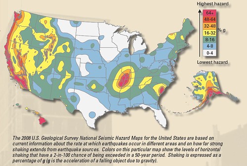
That great big target painted on Middle America, my friends, is the New Madrid Seismic Zone. In 1811, it broke in a big way, so big it caused the Mississippi River to run backwards for a bit. Lots of interesting things happened that weren’t quite so interesting to the people who lived through it. More terrifying. And since then, people have watched that fault with a wary stare. It still kicks from time to time, letting us know the earth isn’t as stable as we’d like. But some studies suggest that those may just be aftershocks, long after the main event, and nothing much to worry about. I wrote that up here, a long time ago when I was a young, fresh science blogger.
The thing about New Madrid is this: it was so dramatic, so unexpected, that we’ve approached it with an overabundance of caution ever since. And until further studies confirm it’s no longer a threat, I personally think we’d be wise to continue to treat it as a potential, even if not probable, problem. And this is an excellent place to study intercontinental earthquakes, which are odd and intriguing, so let the science continue!
Here are some additional links should you wish to investigate further.
Nature: Seth Stein: The quake killer.
Nature: Long aftershock sequences within continents and implications for earthquake hazard assessment (pdf).
Highly Allochthonous: Earthquakes within plates: we don’t know when, and we may not know where.
+/- Science: An Abbreviated Numerical History of the Great New Madrid Earthquakes.

I grew up in Illinois near St. Louis, and we had one big tremor that I can remember. In my area it was only strong enough to maybe knock a few unsecured things off of walls, but it was strong enough that I thought someone had run a car into the house (my room was on an outside wall next to the neighbor’s driveway). Only that one big heave, though. Nothing like the repetitive shaking that “real” earthquakes have.
On a related topic to the precambrian rifting. I have read abstracts that suggest that the Illinois baisin (Paleozoic in time), was caused by cooling of the lithosphere after the rifting event about 800 million years ago. The basin is about 15000 feet deep with Cambrian thru Pennsylvanian sediments (in fact this is where the Illinois coal comes from)
The title of the piece flashed in front of my eyes. New seismic zone in Madrid? WTF? Then I paid attention. Ah, all right, it’s in America. I live in a full respectable seismic zone, no need of new ones nearby. Lisbon.
@3, Carlos: That would be OLD Madrid you’re thinking of. Dana doesn’t mention it in the post, although I’m sure the links do, but the only reason the New Madrid events of 1811 didn’t become better known is that very few (white) people lived there at the time.
For Dana: How about that one in South Carolina? That one I wasn’t familiar with!
Also, the midwestern one is pronounced with the accent on the first syllable – it’s the New MA-drid fault. :)
It is interesting if you read journal articles about New Madrid written in the 1960s the earthquakes were called the biggest in US history, because the were felt over such a large area (rang church bells in Boston, damage in Cincinnati etc). Eventually a few smaller events occurred in the area and using the seismometer recordings it was discovered that seismic waves are transmitted with less loss per mile traveled than in Ca. As a result it was concluded that an event in the mid continent produces a much larger felt area for a given magnitude (really to be correct moment, which is the product of the area that moved and the movement= shear modulus of rocks x area that moved x movement) Once this was discovered the magnitude of the events was reduced. If one things about it the most recent serious tectonics occurring in the area is likely more than 500 million years ago, or if one goes east 200 million years + ago in the Appalachians.
Oooh, thank you! *Tools around in links… learns the term “fault scarp” via context and dramatic illustrations*