
I loves me the Grand Canyon. So when Ron Schott mentioned this on Twitter and someone else reposted it to Facebook, I was a happy human. Nothing like seeing the grandest canyon on Earth from space!
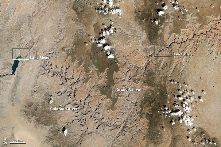
In the image above (top), the Colorado River traces a line across the arid Colorado Plateau. Treeless areas are beige and orange; green areas are forested. The river water is brown and muddy, a common occurrence in spring when melting snows cause water levels to swell and pick up extra sediment. The black line that follows the river in the upper right side of the image is comprised of shadows.
There are two more images! And an absolutely awesome caption. Go see.
How long do you think the Grand Canyon took to form (from a flattish place to a big deep canyon thing, the erosion event, not the layers that are exposed in it)
Followup question: What do you think the highest and lowest values you would be comfortable with are in?
In the region of the grand canyon you mention is also the Diamond Creek access point. Because of a fault that removes the Redwall Limestone and Coconiono Sandstone, it was possible to build a road to the river at this point (The two formations mentioned are big cliff formers). This access is not well known, but the road starts from Peach Springs and goes to the river. Since it is on the reservation it costs about $20 to drive it, or you can take a tour. The access point is one of the few put in take out points on the river.
Much older view, but one of my favorites of the Grand Canyon:
http://bluemonocle.com/antique-maps/p/15631/map-of-grand-canyon-national-park-dutton
Obviously, Greg, it formed in about five minutes during The Flood! Just ask any creationist.
Of course, the Grand Coulee in my state really did form just about that fast.
Just in case some readers can’t locate the part of the Grand Canyon shown, this is the western Grand Canyon, the main viewpoints in the park are east of the picture. Lava Falls is about at Tuweep which is a 3000 foot nearly vertical drop from the rim to the river. Tuweep is 60 miles off paved roads. Interestingly if one looks at the sides of the canyon upstream from the lava dam, one can see what Lake Mead will look like a significant period of time after Hoover Dam goes away. I have not read work on what benches exist along the river upstream.