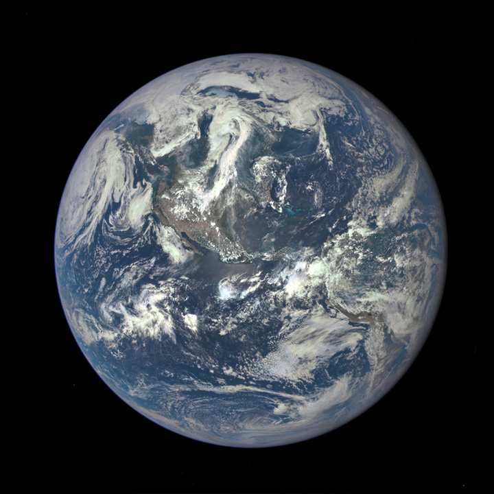
From NASA:
On February 11, 2015, DSCOVR was finally lofted into space by a SpaceX Falcon 9 rocket. After journey of about 1.6 million kilometers (1 million miles) to the L1 Lagrange Point, the satellite and its Earth Polychromatic Imaging Camera (EPIC) has returned its first view of the entire sunlit side of Earth. At L1—four times farther than the orbit of the Moon—the gravitational pull of the Sun and Earth cancel out, providing a stable orbit and a continuous view of Earth. The image above was made by combining information from EPIC’s red, green, and blue bands.(Bands are narrow regions of the electromagnetic spectrum to which a remote sensing instrument responds. When EPIC collects data, it takes a series of 10 images at different bands—from ultraviolet to near infrared.)
This first public image shows the effects of sunlight scattered by air molecules, giving the disk a characteristic bluish tint. The EPIC team is developing data processing techniques that will emphasize land features and remove this atmospheric effect. Once the instrument begins regular data acquisition, new images will be available every day, 12 to 36 hours after they are acquired by EPIC. These images will be posted to a dedicated web page by autumn 2015. Data from EPIC will be used to measure ozone and aerosol levels in Earth’s atmosphere, as well as cloud height, vegetation properties, and the ultraviolet reflectivity of Earth. NASA will use this data for a number of Earth science applications, including dust and volcanic ash maps of the entire planet.
It has not been possible to captures images of the entire sunlit side of Earth at once since Apollo 17 astronauts captured the iconic Blue Marble photograph in 1972. While NASA has released other blue marble images over the years, these have mostly been mosaics stitched together with image processing software—not a single view of Earth taken at one moment in time.
“This first DSCOVR image of our planet demonstrates the unique and important benefits of Earth observation from space,” said NASA Administrator Charles Bolden. “As a former astronaut who’s been privileged to view the Earth from orbit, I want everyone to be able to see and appreciate our planet as an integrated, interacting system.”
The home planet:
I can see my house from here!
But seriously, that is a gorgeous image.
Hey, I can’t see the national borders from up here!
Thanks OB. Lovely.
I have copy/pasted it to a Word document for ease of offline reference.
It is, of course, worth going over the history of DSCOVR.
Originally named Triana, the satellite’s main purpose is to measure Earth’s albedo, that is, the amount of energy reflected from our planet back into space. Knowing this amount is critical to our understanding of global warming. We know how much energy the Earth is receiving form the sun, so knowing how much is sent back into space will tell us Earth’s energy budget, how much heat the planet is absorbing and keeping.
Understand that for decades the AGW denialist crowd has been arguing that without knowing how much heat Earth was reflecting, we couldn’t really, really know if the Earth was heating up. This is a preposterous argument, given how much data we do have, but it is nonetheless an argument that they have regularly put forward.
In a rational world, where AGW denialists were intellectually honest in their doubt, they would support the DSCOVR program. After all, if AGW is wrong, then DSCOVR will prove that in short order. That would be the end of it; they’d be proven right and we could all focus on other things.
So, naturally, they have fought tooth and nail to make sure that DSCOVR never left the ground.
Congressional Republicans dubbed the project “Goresat” and pretending the whole thing was nothing but a multi-million dollar vanity project for Al Gore (who had initially proposed the program to Congress), completely ignoring its scientific merit. They didn’t have enough votes to cancel the project, but they didn’t need them once Bush II took office. He simply cancelled the launch date, whereupon the satellite was moved into a storehouse and kept in freezing conditions to maintain it, on the public’s dime, for almost a decade. Just sitting there, useless.
Europe’s space agency offered to launch it, at no cost to the US government. Various private space agencies offered to launch it, again, for free. The Bush administration just replied that it would be too expensive to, you know, launch it for free, but not too expensive to keep it in liquid nitrogen! For 8 years. All the while, arguing that we can’t know about global warming because, hey, we don’t have the albedo measured!
(This is just one of MANY ways the Bush administration tried to cripple NASA’s Earth science missions. We will be suffering for decades because of this stupidity, but I’ll keep this rant short and not get into all that.)
The good news is that Obama promised early in his campaigning that getting DSCOVR launched would be a goal of his administration, and he lived up to his word. And now it’s where it’s supposed to be, positioned carefully at what scientists call “Lagrange point 1”, where the gravity of the Earth and the sun balance each other.
I’ve been waiting for this. A few days ago I remembered that it was supposed to reach its final orbit around that moment and checked its website, but there wasn’t anything yet.
This is… not entirely correct, or more precisely, it is correct with a few caveats. NASA’s Geostationary Operational Environmental Satellites (GOES) have made pictures of the “entire sunlit side of Earth at once” since the 1990s, but their images are black-and-white. The Russian Elektro-L satellite, launched in 2011, makes color whole disc images. Various NASA probes have also made pictures of the Earth and the Moon from even greater distances, but they probably don’t count, because most of them show the Earth at non-full phase and/or have low resolution.
By the way, to my knowledge suttkus’ summary of the satellite’s history is not entirely correct. Its configuration as launched this year is different from the original Triana and is not quite what Al Gore envisioned when he proposed it:
http://www.nytimes.com/1999/06/01/science/politics-keeps-a-satellite-earthbound.html
The full 1999 article is worth reading, but yeah, one could see why people would attach the idea to Gore even without the climate change politicking.
But that photo is centered on MEXICO! Somebody alert Donald Trump.
Damn, my eyes were closed. Can they take it again?
Hahahahaha
@7. Lady Mondegreen : I’m pretty sure they’ll be taking lots of pictures again and again although it is really surprising that its the first Full Earth image in so long. I’m looking forward to seeing one that’s centred on Australia (my home) – must remember to look up and wave at the right time!
@5. Z & suttkus & Ophelia Benson – thanks for posting the image and all that info & links on it.
@2. Marcus Ranum : Pale Blue Dot as Sagan famously said :
https://www.youtube.com/watch?v=Sbq0WYnph0w
Also what Isaac Asimov said here :
too.
Truth.